Bladensburg National Park
| Bladensburg National Park | ||
|---|---|---|
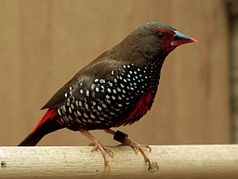
| Painted amadines ( Emblema pictum ) | ||
|
|
||
| Location: | Queensland , Australia | |
| Specialty: | Table land with table mountains and Härtlingen | |
| Next city: | Winton | |
| Surface: | 849 km² | |
| Founding: | 1984 | |
The Bladensburg National Park (English: Bladensburg National Park ) is a national park in the center of the Australian state of Queensland .
location
It is 1,152 kilometers northeast of Brisbane , just south of Winton . The 849 square kilometer area was declared a national park in 1984.
fauna
The most common birds in this area are the painted amadine , the red-brown crowned emu wren ( Stipiturus ruficeps ), and the red-brown- throated honeyeater ( Conopophila rufogularis ).
Terrain forms
In the park there are grass steppes, river plains, sandstone mountains and table mountains . The most important watercourse is the often dried up Surprise Creek . When the floods occur, it becomes an interwoven watercourse .
The area in the south of the park consists of fragmented table land with table mountains and hardnesses . There are large areas of sand further south.
history
Bladensburg was once a sheep breeding station and is now protected as an area with high biodiversity . Most of it belongs to the Goneaway Tablelands sub-region of the Channel Country bioregion , but also includes parts of the Mitchell Grass Downs bioregion . The visitor center is now located in the old farmhouse in Bladensburg, which was probably shipped there in the 1910s.
In the park there are fossil dinosaurs , as well as old Aboriginal camps and ceremonial sites . At the Skull Hole , a waterhole in the park, there was an aboriginal massacre known as the Bladensburg massacre .
Facilities and access
The park is 10 miles from Winton by road. Camping is permitted on the banks of Surprise Creek . Drinking water is not available.
Web links
Individual evidence
- ↑ Australian Government - CAPAD 2010 ( MS Excel ; 170 kB), DSEWPaC , accessed on January 7, 2013 (English)
- ↑ Australian Government - CAPAD 1997 ( MS Excel ; 93 kB), DSEWPaC , accessed on January 7, 2013 (English)
- ↑ a b c d e Peter Shilton: Natural Areas of Queensland . Goldpress, Mount Gravatt, Queensland 2005, ISBN 0-9758275-0-2 , pp. 288-290 (accessed July 7, 2011).
- ↑ a b Bladensburg National Park . Tourism Queensland. Retrieved October 31, 2010.
- ^ A b c Howard Pearce, Kay Cohen, Margaret Cook: Heritage Trails of the Queensland Outback. Queensland Environmental Protection Agency, Brisbane 2002, ISBN 0-7345-1040-3 , p. 75.

