Koombooloomba National Park
| Koombooloomba National Park | ||
|---|---|---|
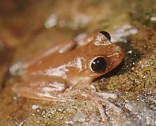
| Australian lace-lid ( Nyctimystes dayi ) | ||
|
|
||
| Location: | Queensland , Australia | |
| Specialty: | Rainforest | |
| Next city: | 34.00 mile (s) from Innisfail | |
| Surface: | 292.81 km² | |
| Founding: | 2010 | |
The Koombooloomba National Park (English Koombooloomba National Park and Conservation Park ) is a 292 square kilometer national park in Queensland , Australia . Since 1988 it has been listed as a UNESCO World Natural Heritage Site Wet Tropics of Queensland because of its natural beauty, biodiversity , evolutionary history and as a habitat for numerous endangered animal species . The park is also part of the Wooroonooran Important Bird Area , which is home to numerous endemic bird species.
location
The park is located in the North Queensland region and is approximately 55 kilometers southwest of Innisfail and 35 kilometers northwest of Tully . It borders immediately to the north on the Tully Falls and Tully Gorge National Park , in the south on the Kirrama National Park . It can be reached via Tully Falls Road, which branches off the Kennedy Highway in Ravenshoe . The 20 km long access road is partly unpaved, has potholes and sharp turns, so vehicles with a high ground clearance are recommended.
fauna
The rainforests are home to over 100 different bird and 40 mammal species. They also form an important refuge for endangered amphibians , such as the Australian lace-lid ( Nyctimystes dayi ), the sharp snouted dayfrog ( Taudactylus acutirostris ) and the tapping green eyed frog ( Litoria serrata ).
history
With the settlement by the Europeans, logging began in today's national park. Above all, the rainforests in the east and the drier parts in the west were extensively cleared, in the areas with the hard-leaf vegetation that is particularly worthy of protection, however, only individual trees were felled, so that the effects are barely visible today.
On March 19, 1967, the area became the Koomboolomba State Forest, to which further parcels were added over time, before it was declared part of the World Heritage Site in 1988. On September 14, 2001, 29,281 hectares became a Forest Reserve , until November 19, 2010, the entire area became a national park.
Koombooloomba Reservoir
After the Second World War , the demand for electricity in northern Queensland increased and the Tully River was chosen as the location for a hydroelectric power station . In the 1950s, the Koombooloombadamm was built, followed by the two turbine stations. The full reservoir has a surface area of 1550 hectares and an average depth of 12.9 meters. A total of 22,500 MWh of energy are generated here each year.
Web links
- Official site of the park (English)
Individual evidence
- ↑ a b Important Bird Areas (IBAs) - Wooroonooran , www.birdlife.org, accessed on October 7, 2012 (English)
- ↑ a b c Official Park Website - About , Queensland Parks and Wildlife Service , accessed October 7, 2012
- ↑ a b c Official Park Website - Culture , Queensland Parks and Wildlife Service , accessed October 7, 2012
- ↑ Species List , Queensland Parks and Wildlife Service , accessed October 7, 2012.

