Gray Peaks National Park
| Gray Peaks National Park | ||
|---|---|---|
|
|
||
| Location: | Queensland , Australia | |
| Specialty: | Rainforest | |
| Next city: | 15 kilometer (s) from Cairns | |
| Surface: | 10.83 km² | |
| Founding: | 2005 | |
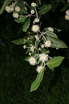
| Turpentine ( Syncarpia glomulifera ) | ||
The Gray Peaks National Park (English Gray Peaks National Park ) is an approximately 11 square kilometer national park in Queensland , Australia . It is part of the Coastal Wet Tropics Important Bird Area .
location
The park is located in the North Queensland region and protects parts of the green hinterland of Cairns and the Mulgrave River Valley. It is about 9 kilometers northeast of Gordonvale and 15 kilometers southeast of Cairns .
The national parks Little Mulgrave , Dinden , Barron Gorge , Frankland Group and Fitzroy-Island are in the vicinity .
flora
Due to the steep, inaccessible terrain, the mosaic of rainforest and hard foliage vegetation was almost completely spared from clearing and logging. The hardwood forest is dominated by "Large-fruited Red Mahogany" ( Eucalyptus pellita ) and "Turpentine" ( Syncarpia glomulifera ) from the myrtle family .
Facilities and access
There is no public access or visitor facilities in the park.
Web links
- Official site of the park (English)
Individual evidence
- ↑ a b Australian Government - CAPAD 2010 ( MS Excel ; 170 kB), DSEWPaC , accessed on October 7, 2012 (English)
- ↑ Important Bird Areas (IBAs) - Coastal Wet Tropics , www.birdlife.org, accessed on October 7, 2012 (English)
- ↑ Official Park Website , Queensland Parks and Wildlife Service , accessed October 7, 2012

