Percy Isles National Park
| Percy Isles National Park | ||
|---|---|---|
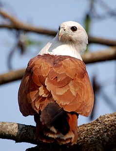
| Brahmin consecration ( Haliastur indus ) | ||
|
|
||
| Location: | Queensland , Australia | |
| Specialty: | Archipelago, birds | |
| Next city: | 125 kilometer (s) from Mackay | |
| Surface: | 35.18 km² | |
| Founding: | 2010 | |
| Brown honey eater ( Lichmera indistincta ) | ||
The Percy Isles National Park (English Percy Isles National Park ) is a 35.18 square kilometer national park in Queensland , Australia . It is part of the Great Barrier Reef , a UNESCO World Heritage Site .
Matthew Flinders named the Percy Isles archipelago after Hugh Percy , 1st Duke of Northumberland, when he circumnavigated Australia on board the HMS Investigator in 1802 .
location
The Percy Isles consist of several small archipelagos, which are spread over an area of about 1,000 square kilometers in the Coral Sea . They are located approximately 125 kilometers southeast of Mackay .
In contrast to the coral islands of the Great Barrier Reef 50 kilometers further east, the Percy Isles are all of continental origin.
The southernmost, second largest island, South Percy Island, is about 50 kilometers from the coast. With a width of 4.5 kilometers and a length of 6.5 kilometers, it is only slightly smaller than the largest island Middle Percy Island with a size of about 6.5 by 6.5 kilometers. There is also the highest point in the archipelago at 184 meters. Especially to the north and east of these two main islands are numerous, much smaller islets.
In the immediate vicinity in the Coral Sea are the South Cumberland Islands , Northumberland Islands and Broad Sound Islands national parks .
Flora and fauna
35 bird species have been counted on the islands, including the endangered soot oystercatcher ( Haematopus fuliginosus ). Observed more frequently are Brahminy Kite ( Haliastur indus ), Langschwanztriel ( Burhinus grallarius ) Salvadorikrähe ( Corvus orru ), greybeard falcon ( Falco cenchroides ), brown honeyeater ( Lichmera indistincta ) and the Boobookkauz ( Ninox boobook ). In addition, the endangered Eulamprus amplus from the skink family is native to the islands.
The higher parts of the islands are covered with dry rainforest, near the coast grass predominates. There are also some endangered species such as Corymbia xanthope from the genus Corymbia or Stackhousia tryonii from the spindle tree family . Orchids such as Dockrillia bowmanii and Geodorum densiflorum grow in the treetops . The grassy areas are dominated by sour grasses and sweet grasses .
Individual evidence
- ↑ a b Australian Government - CAPAD 2010 ( MS Excel ; 170 kB), DSEWPaC , accessed on January 7, 2013 (English)
- ↑ Place name details - PERCY ISLES ( page no longer available , search in web archives ) Info: The link was automatically marked as defective. Please check the link according to the instructions and then remove this notice. , Department of Environment and Resource Management , accessed January 7, 2013
- ↑ a b c Whitsunday and Mackay Islands Visitor Management Strategy - Visitor Management Settings - Map 3 'Mackay' ( Memento of the original from July 23, 2015 in the Internet Archive ) Info: The archive link was inserted automatically and has not yet been checked. Please check the original and archive link according to the instructions and then remove this notice. (PDF file; 1.76 MB), Queensland Parks and Wildlife Service , accessed January 7, 2013 (English)
- ↑ a b Official website of the park - Species List , Queensland Parks and Wildlife Service , accessed October 7, 2012 (English)


