Welford National Park
| Welford National Park | ||
|---|---|---|
| Ghost Gums ( Corymbia dallachiana ) | ||
|
|
||
| Location: | Queensland , Australia | |
| Specialty: | Mulga and mitchell grass, sand dunes and floodplain | |
| Next city: | Windorah | |
| Surface: | 1240 km² | |
| Founding: | 1994 | |
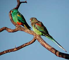
| Multicolored Parakeet | ||
The Welford National Park (English: Welford National Park ) is a national park in the center of the Australian state of Queensland . It is located 991 km west of Brisbane and about 60 km northeast of Windorah .
history
The land was used as pastureland from 1882. The sheep breeding station was called Welford Downs after its founder Richard Welford . Welford himself had named the station Walton . The national park was established in 1992 at the instigation of Claire Gillman . The former Welford Downs Station now serves as accommodation for the national park's staff and can also be visited.
Aboriginal stone patterns and cisterns can still be found in the park today .
National nature
The park is located in the Channel Country on the Barcoo River . In addition to the floodplains, there is also flat land with red sand dunes.
Flora and fauna
Welford National Park protects the plains overgrown with mulga and mitchell grass. "River Red Gums" ( Eucalyptus camaldulensis ) and "Coolibahs" ( Eucalyptus coolabah ) can be found along the river channels and "Ghost Gums" ( Corymbia dallachiana ) have settled on the sand dunes .
The rare yellow-footed rock kangaroo is found in the park as well as the multi-colored parakeet .
Facilities
Wild camping is allowed at two locations on the Barcoo River.
The leisure activities take place mainly around the water holes. Visitors go there by canoes, kayaks and other boats.
Driveway
The park can be reached from Windorah via Diamantina Developmental Road ( Tenham / Thunda exit , 42 km east of Windorah). From there, a 53 km long, unpaved road leads northeast to the southern park entrance. The other way leads over the Thomson Developmental Road (partly unpaved) to Jundah (99 km) and from there on a 21 km long unpaved road south to the northern park entrance.
Individual evidence
- ↑ Australian Government - CAPAD 2010 ( MS Excel ; 170 kB), DSEWPaC , accessed on October 7, 2012 (English)
- ↑ Australian Government - CAPAD 1997 ( MS Excel ; 93 kB), DSEWPaC , accessed on October 7, 2012 (English)
- ^ A b c Steve Parish: Australian Touring Atlas . Steve Parish Publishing. Archerfield QLD 2007. ISBN 978-1-74193-232-4 . P. 17 + 19
- ↑ a b c d Environmental Protection Agency (Queensland): Heritage Trails of the Queensland Outback . State of Queensland, 2002, ISBN 0-7345-1040-3 , p. 165.
- ↑ a b c d e f Welford National Park . Department of Environment and Resource Management. Retrieved December 12, 2012.


