Girraween National Park
| Girraween National Park | ||
|---|---|---|
|
|
||
| Location: | Queensland , Australia | |
| Specialty: | Granite mountains | |
| Next city: | Stanthorpe | |
| Surface: | 118 km² | |
| Founding: | 1932 | |
The Girraween National Park (English: Girraween National Park ) is a national park in the southeast of the Australian state of Queensland .
location
The national park is 150 kilometers southwest of Brisbane and 25 kilometers south of Stanthorpe , and thus directly on the border with New South Wales . The Bald Rock National Park connects to the southeast .
National nature and climate
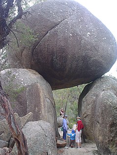
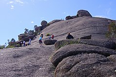
The park area is part of the granite belt . You can find steep cliffs such as The Pyramids or Castle Rock with a height of 1,112 meters that dominate the scenery. Other mountains include The Sphinx, Turtle Rock, Eye of the Needle, South Bald Rock, West Bald Rock and the highest mountain, Mount Norman at 1,267 meters. In between there are clear streams, wetlands and waterfalls.
The national park has a temperate climate. Snow can fall in winter.
Flora and fauna
The mountains are overgrown with eucalyptus forest and heathland, which offer a habitat for a rich bird life. Many wildflowers bloom in spring, so the Aboriginal name of the area means flower place . Only in this area does the "Wallangarra Whitegum" ( Eucalyptus scoparia ) grow .
The park is rich in wildlife. You can also see animals that are rare in Queensland, such as the wombat , the giant pouch marten , the lyre-tail and the beautiful parakeet .
In 1992, employees of the Taronga Zoo discovered the tortoise species Myuchelys bellii in the Girraween National Park.
free time activities
The national park is ideal for hiking and mountaineering, as there are many kilometers of hiking trails. In the south and east of the park you can even hike along the fire protection paths.
Web links
- Official site of the park (English)
- Girraween National Park . Rymich.com
- Girraween National Park - QLD . exploroz.com
literature
- CR Twidale, Juan Ramón Vidal Romaní: Landforms and Geology of Granitic Terrains . CRC Press, 2005, ISBN 0-415-36435-3 .
Individual evidence
- ↑ Australian Government - CAPAD 2010 ( MS Excel ; 170 kB), DSEWPaC , accessed on January 7, 2013 (English)
- ↑ Australian Government - CAPAD 1997 ( MS Excel ; 93 kB), DSEWPaC , accessed on January 7, 2013 (English)
- ^ Steve Parish: Australian Touring Atlas . Steve Parish Publishing. Archerfield QLD 2007. ISBN 978-1-74193-232-4 . P. 9
- ^ Seeing South-East Queensland , 2nd edition, RACQ, 1980, ISBN 0-909518-07-6 , p. 73.
- ^ A b c d Greg Reid: Australia's National and Marine Parks: Queensland . Macmillan Education Australia, South Yarra VIC 2004, ISBN 0-7329-9053-X , p. 22.
- ^ Rare Species (Transcript) In: Stateline . Australian Broadcasting Corporation. April 26, 2006. Archived from the original on May 7, 2006. Info: The archive link was automatically inserted and not yet checked. Please check the original and archive link according to the instructions and then remove this notice. Retrieved August 30, 2008.


