Amamoor National Park
| Amamoor National Park | ||
|---|---|---|
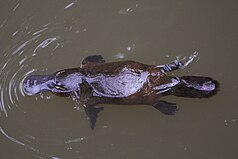
| platypus | ||
|
|
||
| Location: | Queensland , Australia | |
| Specialty: | Platypuses, rainforest | |
| Next city: | 15 kilometer (s) from Gympie | |
| Surface: | 38 ha | |
| Founding: | 2006 | |
The Amamoor National Park (English Amamoor National Park ) is a 38 hectare national park in Queensland , Australia .
location
Located in the Wide Bay-Burnett region , it is 130 kilometers north of Brisbane and 115 kilometers south of Hervey Bay . From the Bruce Highway about 20 km south of branches Gympie the road in the same place Amamoor from. From here, following Amamoor Creek Road , the Amamoor State Forest is ten kilometers away .
The national parks Glastonbury , Conondale , Wrattens and Woondum are in the vicinity .
Facilities
The State Forest has two campsites and several designated hiking trails. The neighboring national park has no visitor facilities.
Flora and fauna
The national park protects subtropical rainforest up to 330 meters above sea level , dominated by cedar trees ( white cedar ), toona ciliata ( red cedar ), New Guinea araucarias ( hoop pine ) and Queensland araucarias ( bunya pine ). In the streams can be the shy platypus watching. The wetter areas are also home to some rare or endangered species of frog.
Individual evidence
- ↑ a b CAPAD 2010 . ( MS Excel ; 170 kB) Australian Government, DSEWPaC , accessed on October 7, 2012 (English)
- ↑ Amamoor Area Map . (PDF; 127 kB), Queensland Parks and Wildlife Service , accessed on October 7, 2012 (English)
- ↑ a b About . Queensland Parks and Wildlife Service , accessed October 7, 2012

