Littabella National Park
| Littabella National Park | ||
|---|---|---|
|
|
||
| Location: | Queensland , Australia | |
| Specialty: | Coastal hilly landscape with lagoons | |
| Next city: | Bundaberg | |
| Surface: | 83.4 km² | |
| Founding: | 1980 | |
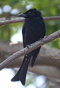
| Drongo ( Dicrurus bracteatus ) | ||
The Littabella National Park (English: Littabella National Park ) is a national park in the southeast of the Australian state of Queensland .
location
It is 336 kilometers north of Brisbane and about 50 kilometers northwest of Bundaberg .
National nature
The national park consists of hilly terrain, the highest point of which reaches 35 meters above sea level. In between there is swampy lowland with small lagoons, some of which can also dry out.
Flora and fauna
In the lowlands of the park you can find light forest with banksias and myrtle heaths . The myrtle heather and eucalyptus forest dominate the higher elevations .
The following species are found in the National Park: Sugar Glider , Hörnchengleitbeutler ( Petaurus norfolcensis ) Gold abdominal hydromys ( Hydromys chrysogaster ), Wonga Pigeon , Banks calyptorhynchus , Glanzspitzendrongos ( Dicrurus bracteatus ) Frillneck , Northern Banjo Frogs ( Lymnodynastes terraereginae ) and Wallumfröschchen ( Crinia tinnula ).
Driveway
The national park near the coast can be reached via the Bundaberg - Miriam Vale road near Warragan .
Individual evidence
- ↑ Australian Government - CAPAD 2010 ( MS Excel ; 170 kB), DSEWPaC , accessed on October 7, 2012 (English)
- ↑ Australian Government - CAPAD 1997 ( MS Excel ; 93 kB), DSEWPaC , accessed on October 7, 2012 (English)
- ^ A b Steve Parish: Australian Touring Atlas . Steve Parish Publishing. Archerfield QLD 2007. ISBN 978-1-74193-232-4 . P. 11
- ↑ a b c Littabella National Park - Management Plan (PDF; 927 kB). Queensland Parks and Wildlife Service. Queensland Government (August 2000)

