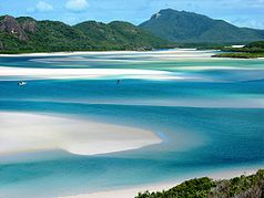
Whitsunday Islands National Park
| Whitsunday Islands National Park | ||
|---|---|---|
| Hill Inlet | ||
|
|
||
| Location: | Queensland , Australia | |
| Specialty: | Tropical islands | |
| Next city: | Proserpine - Mackay | |
| Surface: | 170 km² | |
| Founding: | 1944 | |
The Whitsunday Islands National Park is a national park in Queensland ( Australia ), 926 km northwest of Brisbane . The region stretches from the beaches of Bowen in the north to Laguna Whitsundays in the south. It consists of a charming island world, the Whitsunday Islands on the Australian east coast, which is known for its white sandy beaches and crystal clear water.
The national parks of Molle Islands , Lindeman Islands and Gloucester Island are in the vicinity .
fauna
Migratory humpback whales prefer the waters around the Whitsunday Islands as a calving area between May and September each year. Box jellyfish colonize the water between October and May.
Web links
Commons : Whitsunday Islands National Park - Collection of pictures, videos, and audio files
- Official website (English)
Individual evidence
- ↑ Australian Government - CAPAD 2010 ( MS Excel ; 170 kB), DSEWPaC , accessed on October 7, 2012 (English)
- ↑ Australian Government - CAPAD 1997 ( MS Excel ; 93 kB), DSEWPaC , accessed on October 7, 2012 (English)
- ↑ Whitsunday and Mackay Islands Visitor Management Strategy - Visitor Management Settings - Map 2 'Whitsunday' ( Memento of the original from July 24, 2015 in the Internet Archive ) Info: The archive link was inserted automatically and has not yet been checked. Please check the original and archive link according to the instructions and then remove this notice. (PDF; 1.2 MB), Queensland Parks and Wildlife Service , accessed January 7, 2013
- ↑ a b Explore Queensland's National Parks . Explore Australia Publishing, Prahran, Victoria 2008, ISBN 978-1-74117-245-4 , p. 19.

