Bruxner Highway
| Bruxner Highway | |
|---|---|

|
|
| map | |
| Basic data | |
| Operator: | Roads and Maritime Services |
| Start of the street: |
west of Ballina ( NSW ) ( 28 ° 52 ′ S , 153 ° 30 ′ E ) |
| End of street: |
Boggabilla ( NSW ) ( 28 ° 36 ′ S , 150 ° 22 ′ E ) |
| Overall length: | 419 km |
|
States : |
|
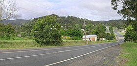
| Bruxner Highway near Drake | |
The Bruxner Highway is a trunk road in the northeast of the Australian state of New South Wales . It runs along the border with Queensland in an east-west direction and connects the Pacific Highway at Ballina with the Newell Highway in Boggabilla and thus the Northern Rivers region with the plateaus of the Northern Tablelands .
Origin of name
It is named after Michael Bruxner , longtime chairman of the National Party of Australia and former Minister of Transport.
course
The Bruxner Highway begins in the east at the junction with the Pacific Highway (R1) at Ballina, where it branches off to the west-northwest. In Lismore it turns sharply to the south, and soon afterwards again to the west-northwest. At Casino , the road crosses the Richmond River and Summerland Way (S91) and continues west through Richmond Range National Park and Mallanganee National Park . At Tabulam the highway crosses the Clarence River and turns west-southwest. Between Timbarra National Park , Boonoo Boonoo National Park and Bald Rock National Park , it leads over the ridge of the Great Dividing Range to Tenterfield , where it meets the New England Highway (N15).
The Bruxner Highway runs for a short distance to the northwest, together with the New England Highway, then turns west again and follows Tenterfield Creek and the Mole River to the place of the same name on the Queensland border. This boundary, which is formed by the Dumaresq River , follows the road in an arc to the south, west, north and finally northwest to south of the city of Texas . There it turns west again and crosses the Macintyre River at Yetman . There the Warialda Road (S95) joins from the south . The Bruxner Highway follows the southwest bank of the river to Boggabilla , again on the Queensland border and south of Goondiwindi , where it meets and ends on the Newell Highway (N39).
Important junctions and junctions
|
Bruxner Highway |
|||
| Connections to the west | Distance to Goondiwindi (km) |
Distance to Tenterfield (km) |
Connections to the east |
|
At the end of the Bruxner Highway, continue as Newell Highway to Goondiwindi / St. George / Brisbane |
8th | 235 |
Beginning of the Bruxner Highway from the Newell Highway |
|
Moree , Dubbo , Melbourne Newell Highway |
|||
| Boggabilla | |||
| North Star, Warialda Boggabilla-Warialda Road |
24 | 219 | North Star, Warialda Boggabilla-Warialda Road |
|
Warialda , Inverell Warialda Road |
68 | 175 |
Warialda , Inverell Warialda Road |
| Yetman | 69 | 174 | Yetman |
|
Texas , Inglewood, Stanthorpe Inglewood-Texas Road |
108 | 135 |
Texas , Inglewood, Stanthorpe Inglewood-Texas Road |
| Bonshaw | 133 | 110 | Bonshaw |
| Ashford, Inverell Inverell-Bonshaw Road |
137 | 106 | Ashford, Inverell Inverell-Bonshaw Road |
|
further than |
238 | 5 | Stanthorpe, Warwick , Brisbane New England Highway |
|
Stanthorpe , Warwick , Brisbane New England Highway |
|
||
| Woodenbong Mount Lindesay Road |
242 | 1 | Woodenbong Mount Lindesay Road |
| Connections to the west | Distance to Tenterfield (km) |
Distance to Ballina (km) |
Connections to the east |
|
|
0 | 190 | Tenterfield |
|
Tamworth , Newcastle , Sydney New England Highway |
Tamworth , Newcastle , Sydney New England Highway |
||
| Tenterfield |
further than |
||
| Drake | 50 | 140 | Drake |
| Tabulam | 69 | 121 | Tabulam |
| Baryulgil, Grafton Clarence Way |
79 | 111 | Baryulgil, Grafton Clarence Way |
| Bonalbo, Urbenville Woodenbong Road |
81 | 109 | Bonalbo, Urbenville Woodenbong Road |
| Mallanganee | 88 | 102 | Mallanganee |
| SYDNEY-BRISBANE RAILWAY LINE |
125.5 | 64.5 | SYDNEY-BRISBANE RAILWAY LINE |
|
further than |
126.5 | 63.5 |
Grafton Summerland Way |
|
Grafton Summerland Way |
|
||
| Casino | 127 | 63 | Casino |
|
|
128 | 62 |
Kyogle , Woodenbong Summerland Way |
|
Kyogle , Woodenbong Summerland Way |
further than |
||
|
Kyogle , Nimbin Union Street |
157 | 33 |
Kyogle , Nimbin Union Street |
| Clunes, Bangalow, Byron Bay Dawson Street |
158 | 32 | Lismore |
| Lismore | Clunes, Bangalow, Byron Bay Dawson Street |
||
| Wollongbar | 174 | 16 | Wollongbar |
| Alstonville | 177 | 13 | Alstonville |
|
Start of the Bruxner Highway |
184 | 6th |
End of the Bruxner Highway |
|
Pacific Highway to Ballina , Gold Coast and Brisbane Pacific Highway to Grafton , Coffs Harbor and Sydney |
|||
Web links
source
Steve Parish: Australian Touring Atlas . Steve Parish Publishing. Archerfield QLD 2007. ISBN 978-1-74193-232-4 . P. 28 + 29
Individual evidence
- ^ Don Aitkin: Bruxner, Sir Michael Frederick (1882-1970) . In: Australian Dictionary of Biography . Australian National University . Retrieved October 9, 2011.
- ↑ Bruxner Highway , Ozroads: the Australian Roads website . Retrieved October 9, 2011.

