
Australian Capital Territory
| flag | coat of arms |
|---|---|

|

|
| ( Details ) | ( Details ) |
| Basic data | |
| Capital : | Canberra |
| Area : | 2,358 km² |
| Residents : | 415,900 (Dec 2017) |
| Population density : | 176.4 inhabitants per km² |
| ISO 3166-2 : | AU-ACT |
| The highest point: | Bimberi Peak 1,912 m |
| Official Website: | www.act.gov.au |
| politics | |
| Head of Government : | Andrew Barr ( ALP ) |
| Parliament seats: | 2 ( House of Representatives ) 2 ( Senate ) |
| map | |
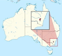 .svg) |
|
The Australian Capital Territory ( ACT , German Australian Capital Territory ) is an Australian territory in which the capital Canberra is located.
The ACT is a 2358 km² enclave and is completely enclosed by the eastern Australian state of New South Wales .
Self-management
The ACT has its own government, but does not have the full independence of the Australian states. The area is governed by a Council of Ministers . The Chief Minister has been provided by the Australian Labor Party since 2001 . Laws are passed by a 25-member parliament, the Australian Capital Territory Legislative Assembly , which is basically responsible for all areas of responsibility of the member states, but is also empowered at the local level. However, resolutions of the ACT can be overridden by federal law. The British Crown is different from other Australian territories such as B. Represented by the Australian Governor General on Norfolk Island , Christmas Island or the Cocos Islands . The ACT is represented by two members each in the Senate and in the House of Representatives (constituencies Fraser and Canberra ). The Fraser MP and Senators also represent the people of the Jervis Bay Territory . The official symbols of the territory are the Royal Bluebell plant (Wahlenbergia gloriosa) and the cockatoo .
history

Before European settlement began in the 1820s, the area of today's ACT was inhabited by three Aboriginal tribes, the Ngunnawal , the Walgalu and the Ngarigo . From 1824 onwards, settlements, farms and finally small towns developed. A farm of particular historical importance was Lambrigg near Tharwa; here, William Farrer bred a rust- resistant wheat variety that helped wheat cultivation in Australia to break through.
During the negotiations on the constitution of the Australian Confederation (Commonwealth of Australia), the two largest cities Melbourne and Sydney wanted to become the capital of the newly established state. A compromise finally envisaged building the new capital between the two cities. The constitution provided for the city to be built in New South Wales but at least 100 miles from Sydney. Melbourne became the temporary capital of Australia until a suitable location was found.

In 1908 the current location was chosen. In 1909 New South Wales ceded the intended land to the federal government and in 1910 Parliament created the legal basis for the formation of the territory. This was initially called the Federal Capital Territory and was given its current name in 1938. Home Secretary King O'Malley enforced an alcohol ban in the Territory that lasted until 1928.
In April 1911, O'Malley wrote an international design competition for the new capital, which the American architect Walter Burley Griffin won. After the surveying work had started on February 20, 1913, the governor-general's wife baptized the future city on March 12, 1913 with the name Canberra. In 1915, the coastal Jervis Bay Territory was acquired to give the capital access to the sea.
With the official opening of the provisional parliament building ( Old Parliament House ) on May 9, 1927 , the federal government moved to Canberra, which was the new capital of Australia from that day on. Little by little, the rest of the federal administration also moved to the ACT. One of the first official acts of the new parliament was the repeal of the prohibition laws.
In 1988 the territory was granted the right to self-government, although this had been rejected ten years earlier in a vote by 63%.
The January 2003 bushfires wreaked havoc in the city and in rural ACT areas to the west; over 500 buildings were destroyed.
Attractions

Outside the city of Canberra there are extensive agricultural areas in the ACT, which are mainly used for sheep breeding and dairy farming ; there are also some vineyards . Large parts of Canberra are covered by the mountainous Namadgi National Park , which is covered with a lot of forest, and the Tidbinbilla Nature Reserve . The highest point is the summit of Mount Bimberi with a height of 1912 meters.
Localities within the territory are Williamsdale , Naas , Tharwa and Hall . Which is located directly on the border to Tidbinbilla Nature Reserve Canberra Deep Space Communication Complex (CDSCC), part of the worldwide Deep Space Network of NASA .
Universities
- Australian National University (ANU), Canberra
- University of Canberra (UC), Canberra
- Australian Catholic University (ACU), Signadou Campus, Canberra
- Charles Sturt University , Canberra Campus, Canberra
- Australian Defense Force Academy (ADFA), Canberra
See also
Web links
- The ACT Government website (English)
Individual evidence
- ↑ 3101.0 - Australian Demographic Statistics, Dec 2017 , accessed June 28, 2015.
States:
New South Wales |
Queensland |
South Australia |
Tasmania |
Victoria |
Western Australia
Territories:
Australian Capital Territory |
Jervis Bay Territory |
Northern Territory
Outskirts:
Ashmore and Cartier Islands |
Australian Antarctic Territory |
Heard and McDonald Islands |
Coconut Islands |
Coral Sea Islands |
Norfolk Island |
Christmas Island