
Coral Sea Islands
| Coral Sea Islands Territory | |||||
| Coral Sea Islands | |||||
|
|||||
| Official language | English | ||||
| Form of government | Australian outskirts | ||||
| Head of state , also head of government | Elizabeth II | ||||
| surface | 780,000 km² | ||||
| population | 3 to 4 (ward staff) | ||||
| Internet TLD | no own | ||||
 _(small_islands_magnified)_(Polynesia_centered).svg) |
|||||
 |
|||||

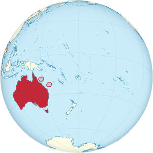
The Coral Sea Islands are a group of small, tropical islands and reefs in the Coral Sea , northeast of Australia . They are spread over a sea area of around 780,000 square kilometers and have a land area of 3 km². There is no port on any of the islands, there are only anchorages off the coast . With an area of 37 hectares, South East Cay in the Magdelaine Cays group is the largest of these islands. The only inhabited island is Willis Island , on it is the manned weather station Willis Islandwith a crew of four people. The islands also have important nesting sites for birds and turtles , but the islands' natural resources are negligible.
politics
The archipelago belongs to Australia as territory and is administered from Canberra by the Australian Department of the Environment , which monitors the activities of visitors. The territory was created in 1969 (previously the islands were considered part of Queensland ) and expanded in 1997 to include the reefs or atolls Middleton and Elizabeth Reef further south , which are often included in the Tasman Sea . Defense is subject to Australia and the Royal Australian Navy periodically controls the islands. The abbreviation for the territory is CR .
Facilities
Australia operates automatic weather stations on many of the islands and reefs and claims a 200 nautical mile fishing zone.
population
There is no permanent population on the islands other than the crew of the Willis Island meteorological station and no economic activity.
See also
- Gay & Lesbian Kingdom of the Coral Sea Islands (self-proclaimed "Kingdom")
Web links
States:
New South Wales |
Queensland |
South Australia |
Tasmania |
Victoria |
Western Australia
Territories:
Australian Capital Territory |
Jervis Bay Territory |
Northern Territory
Outskirts:
Ashmore and Cartier Islands |
Australian Antarctic Territory |
Heard and McDonald Islands |
Coconut Islands |
Coral Sea Islands |
Norfolk Island |
Christmas Island

Member States of the United Nations
Australia |
Fiji |
Indonesia 1 |
Kiribati |
Marshall Islands |
Micronesia |
Nauru |
New Zealand |
Palau |
Papua New Guinea |
Solomon Islands |
Samoa |
Tonga |
Tuvalu |
Vanuatu
Other areas
American Samoa (US) |
Baker Island (US) |
Cook Islands (NZ) |
French Polynesia (FR) |
Guam (US) |
Hawaii (US) |
Howland Island (US) |
Jarvis Island (US) |
Johnston Island (US) |
Kingman attack (US) |
Coral Sea Islands (AU) |
Midway Islands (US) |
New Caledonia (FR) |
Niue (NZ) |
Northern Mariana Islands (US) |
Norfolk Island (AU) |
Easter Island (CL) |
Palmyra (US) |
Pitcairn Islands (UK) |
Tokelau (NZ) |
Wake (US) |
Wallis and Futuna (FR) |
Western New Guinea (ID)
1 Mostly located in Asia .
Coordinates: 19 ° 5 ′ S , 150 ° 54 ′ E