
Shoalhaven River
| Shoalhaven River | ||
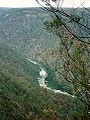
 Shoalhaven River west of Batemans Bay |
||
| Data | ||
| location | New South Wales , Australia | |
| River system | Shoalhaven River | |
| source | at Middle Mountain in the Great Dividing Range 35 ° 57 ′ 26 ″ S , 149 ° 39 ′ 50 ″ E |
|
| Source height | 864 m | |
| muzzle |
Tasman Sea near Nowra Coordinates: 34 ° 54 ′ 6 " S , 150 ° 45 ′ 49" E 34 ° 54 ′ 6 " S , 150 ° 45 ′ 49" E |
|
| Mouth height | 0 m | |
| Height difference | 864 m | |
| Bottom slope | 2.6 ‰ | |
| length | 327 km | |
| Left tributaries | Jinden Creek, Krawaree Creek, Stony Creek, Jerrabattgulla Creek, Witts Creek, Bourkes Creek, Stony Creek, Bombay Creek, Spring Creek, Reedy Creek, Gilberts Creek, Sandy Creek, Boro Creek, Spring Creek, Little Timberlight Creek, Jerralong Creek, Spring Creek, Kangaroo River | |
| Right tributaries | Tallaganda Creek, Bald Hill Creek, Back Creek, Jembaicumbene Creek, Gilbert Creek, Gillamatong Creek, Columbo Creek, Durran Durra Creek, Fairleys Creek, Mongarlowe River , Ningee Nimble Creek, Corang River , Bindi Brook, Endrick River , Ettrema Creek, Calymea Creek | |
| Reservoirs flowed through | Lake Yarrunga | |
| Medium-sized cities | Braidwood, Nowra | |
| Small towns | Oranmeir, Togganoggara, Ballalaba, Jinglemoney, Charleyong, Bomaderry, Shoalhaven Heads | |
The Shoalhaven River is a river in the southeast of the Australian state of New South Wales .
It rises in the southern plateau of New South Wales and flows into the Tasman Sea at Nowra on the coast of New South Wales .
history
The explorer George Bass found the mouth of the Shoalhaven River in 1797 on a trip in his whaling boat down the New South Wales coast. He named the river Shoals Haven because of the muddy and sandy shoals he found in the mouth. Today this estuary is called the Crookhaven River .
geography
The Shoalhaven River rises on the eastern slopes of the Great Dividing Range about 350 km south of Sydney . In the upper reaches, it flows north through pastureland in the highlands near Braidwood . East of Goulburn , the river enters Morton National Park and turns its course to the east, where it has carved a narrow, inaccessible gorge into the plateau. At Nowra in the Local Government Area Shoalhaven City, it pours into the coastal lowlands. There the historic Nowra Bridge spans it .
Berry Canal
The river's estuary has two entrances, the southern one at Crookhaven Heads , which is always open, and the northern one at Shoalhaven Heads , which can only be passed at high tide. The two entrances are 5 km apart and about 150 km south of Sydney.
A short canal between the Shoalhaven River and the Crookhaven River was built in June 1882 by a group of convicts overseen by Hamilton Hume , under the direction of Alexander Berry , to facilitate the transport of goods to the European settlement there, Coolangatta Estate . Comorong Island was created through the construction of the canal . The canal was built using simple tools and was the first navigable artificial canal in Australia. To date, only one more navigable canal has been added in New South Wales, the Alexandra Canal near Sydney.
Use for water supply
The Lake Yarrunga defined by the Tullowa Dam was dammed, is the only major reservoir on the Shoalhaven River and part of the Shoalhaven system . It lies on the lower reaches and serves to supply drinking water to the greater Sydney area. Some of the water from the lake is pumped across the highlands into Lake Burragorang . Plans for a much larger reservoir at Welcome Reef on the upper reaches of the river have been abandoned.
environment
The Shoalhaven River and its main tributary, the Kangaroo River , were once known as good fishing waters for the Australian perch . Unfortunately, the Tullowa Dam presents an insurmountable barrier to migratory fish that spend their youth in the sea or an estuary, such as the Australian perch. The dam prevents them from accessing more than 80% of their previous habitat in the Shoalhaven River system. The release of farmed perch in Lake Yarrunga in November 2008 was an attempt to improve this situation. In August 2009 a fish ladder was installed at the Tullowa Dam. Lake Yarrunga has also suffered from the illegal use of very harmful, exotic carp , which are found there in very large numbers today.
River crossings
The following roads and modes of transport cross the Shoalhaven River (ordered downstream):
- The Warri Bridge on the Kings Highway spans the river at Braidwood. At this point a bridge was opened for the first time on September 23, 1874 and was later replaced by the current bridge.
- Steward's Crossing is a ford along the Steward's Crossing Road .
- Oallen Crossing is a single lane wooden bridge on Oallen Ford Road near Nerriga that was built in 1936.
- The Nowra Bridge spans the river on the Princes Highway between Bomaderry and Nowra.
- The Comorong Island Ferry brings passengers and cars to Comerong Island in the estuary.
Shoalhaven River Gorge at Bundanoon

Shoalhaven River at Nowra

Shoalhaven River with paddle boats


See also
literature
PC Gehrke, DM Gilligan & M. Barwick: Changes in fish communities of the Shoalhaven River 20 years after construction of Tallowa Dam, Australia . River Research and Applications. Volume 18 (2002). Pp. 265-286
Web links
Individual evidence
- ↑ a b c Map of Shoalhaven River, NSW . Bonzle.com
- ^ The Brisbane Courier . July 26, 1924. p. 19
- ^ Estuaries in NSW . NSW Department of Natural Resources ( Memento of the original from October 13, 2009 in the Internet Archive ) Info: The archive link was inserted automatically and has not yet been checked. Please check the original and archive link according to the instructions and then remove this notice.
- ↑ Berry, Alexander (1781-1873) . Australian Dictionary of Biography
- ^ NSW's First Fish Lift to Save the Endangered Grayling . Sydney Catchment Authority ( Memento of the original from March 21, 2012 in the Internet Archive ) Info: The archive link was inserted automatically and has not yet been checked. Please check the original and archive link according to the instructions and then remove this notice.
- ↑ Improving Fish Passage in the Shoalhaven . NSW Department of Primary Industries (PDF; 487 kB)
- ^ The Opening of the Warri Bridge . The Sydney Morning Herald (September 28, 1874). P. 3