Tamar River (Bass Strait)
| Tamar River | ||
|
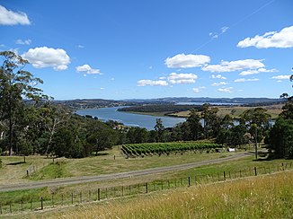
Tamar River and the Wine Route in the Tamar Valley (near Exeter) |
||
| Data | ||
| location | Tasmania ( Australia ) | |
| River system | Tamar River | |
| Drain over | Tamar River → Bass Strait | |
| source |
Launceston 41 ° 26 ′ 5 ″ S , 147 ° 7 ′ 40 ″ E |
|
| Source height | 0 m | |
| muzzle | Port Dalrymple ( Bass Street ) at Low Head Coordinates: 41 ° 4 ′ 18 ″ S , 146 ° 47 ′ 17 ″ E, 41 ° 4 ′ 18 ″ S , 146 ° 47 ′ 17 ″ E |
|
| Mouth height | 0 m | |
| Height difference | 0 m | |
| Bottom slope | 0 ‰ | |
| length | 65 km | |
| Left tributaries | South Esk River , Corniston Creek, Muddy Creek, Stony Brook, Supply River , Anderson Creek, York Town Rivulet | |
| Right tributaries | North Esk River , Banards Creek, Lady Nelson Creek, Symons Creek, Fourteen Mile Creek | |
| Big cities | Launceston | |
| Medium-sized cities | Beaconsfield , George Town | |
| Small towns | Bell Bay | |
| Communities | Dilston, Rosevears, Gravelly Beach, Paper Beach, Robigana, Hillwood, Deviot, Sidmouth, Kayena, Rowella, Beauty Point, Iffraville, Clarence Point, Kelso, Greens Beach, Low Head | |
| Ports | George Town , Launceston | |
| Navigable | to Launceston | |
| The river is an estuary along its entire length . | ||
The Tamar River is a river in the north of the Australian island of Tasmania in the state of the same name, which runs through the Tamar Valley to the north.
geography
River course
It has its origin in Launceston , where the North Esk River and the South Esk River converge. It is about 65 km long and flows to the northwest. At Low Head , near George Town , it joins Bass Street .
Strictly speaking, the Tamar River is not a river, but an estuary , a transitional body of water at the mouth of a river into the open sea. Its water is salty and tidal along its entire length .
Some of the wetlands, lagoons and islands along the Tamar River are now part of the Tamar River Conservation Area and are administered by the Tasmanian Environmental Protection Agency.
Tributaries with mouth heights
- South Esk River - 0 m
- North Esk River - 0 m
- Corniston Creek - 0 m
- Banard Creek - 0 m
- Lady Nelson Creek - 0 m
- Symons Creek - 0 m
- Muddy Creek - 0 m
- Stony Brook - 0 m
- Supply River - 0 m
- Fourteen Mile Creek - 0 meters
- Anderson Creek - 0 m
- York Town Rivulet - 0 m
Origin of name
The river is named after the river Tamar of the same name , which also flows past a place called Launceston , on the border between the counties of Devon and Cornwall in England .
Web links
Individual evidence
- ↑ a b c d Map of River Tamar, TAS . Bonzle.com
- ^ Steve Parish: Australian Touring Atlas . Steve Parish Publishing, Archerfield QLD 2007. ISBN 978-1-74193-232-4 . P. 55
- ^ Tamar River Conservation Area - Highlights. Retrieved February 17, 2010 .
