South Esk River
| South Esk River | ||
|
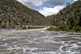
Flood in the South Esk River in Cataract Gorge |
||
| Data | ||
| location | Tasmania ( Australia ) | |
| River system | Tamar River | |
| Drain over | Tamar River → Bass Strait | |
| source | Mathinna Plains (southwest of Mount Victoria Forest Reserve) 41 ° 20 ′ 58 ″ S , 147 ° 46 ′ 30 ″ E |
|
| Source height | 810 m | |
| muzzle |
Tamar River in Launceston Coordinates: 41 ° 26 ′ 5 " S , 147 ° 7 ′ 40" E 41 ° 26 ′ 5 " S , 147 ° 7 ′ 40" E |
|
| Mouth height | 0 m | |
| Height difference | 810 m | |
| Bottom slope | 3.2 ‰ | |
| length | 255 km | |
| Left tributaries | Merry Creek, Dans Rivulet, Claytons Creek, Evercreech Rivulet, Break O'Day River , Fingal Rivulet, Tollochgorum Creek, Rostrevor Rivulet, St. Pauls River , Stynes Creek, Salisbury Rivulet, Macquarie River , Back Creek, Meander River | |
| Right tributaries | Tombstone Creek, Memory Creek, Milly Brook, Jimmys Creek, Tyne River , Sling Pot Rivulet, Coxs Creek, Pig Creek, Mullens Creek, Tower Rivulet, Abbotsford Creek, Burnt Gully Creek, Sawpit Creek, Storys Creek, Castle Cary Rivulet, Buffalo Brook , Ben Lomond Rivulet, Barton Creek, Nile River , Black Forest Creek, Boyes Creek | |
| Reservoirs flowed through | Lake Trevallyn | |
| Big cities | Launceston | |
| Medium-sized cities | Evandale, Perth, Longford | |
| Small towns | Upper Esk, Mathinna, Fingal, Avoca | |
| Communities | Clarendon | |
|
South Esk River near Fingal (aerial view from the southeast) |
||
The South Esk River is a river in the east of the Australian state of Tasmania . At over 250 km, it is the longest river on the island.
geography
River course
The river has its source at Mathinna Plains, southwest of the Mount Victoria Forest Reserve , about 52 km east of Launceston . From there it describes an arc from west to south to east around Mount Saddleback and flows through the small town of Upper Esk on the south side of the mountain. There it begins a large arc over east, south, west and northwest around the Ben Lomond National Park . It flows through the cities of Mathinna , Fingal - where it meets the Esk Highway (A4) -, Avoca and Evendale . In Evendale, 18 km southeast of Launceston, it turns its course west, flows through Perth and Longford , where it turns north, and on into Lake Trevallyn , a reservoir in the western suburbs of Launceston.
The lake, through which most of the river's water flows, is used to supply the city with electricity. Its outflow is discharged north of the city into the Tamar River . Some of the water from the South Esk River flows through Cataract Gorge , a canyon southwest of downtown. From there it flows into downtown Launceston where it merges with the waters of the North Esk River to form the Tamar River. Before the reservoir was built, the South Esk River often flooded the gorge up to 12 m high. Today the overflow water forms remarkable rapids that are located in a city park.
Tributaries with mouth heights
- Tombstone Creek - 435 m
- Memory Creek - 400 meters
- Milly Brook - 353 m
- Jimmy's Creek - 323 m
- Merry Creek - 309 m
- Tyne River - 302 m
- Sling Pot Creek - 290 m
- Dans Rivulet - 290 m
- Claytons Creek - 270 m
- Evercreech Rivulet - 265 m
- Coxs Creek - 253 m
- Pig Creek - 240 m
- Mullens Creek - 234 m
- Break O'Day River - 232 m
- Fingal Rivulet - 229 m
- Tower Rivulet - 223 m
- Tollochgorum Creek - 221 m
- Abbotsford Creek - 219 m
- Burnt Gully Creek - 214 m
- Rostrevor Rivulet - 211 m
- Sawpit Creek - 209 meters
- Stories Creek - 204 m
- Castle Cary Rivulet - 195 m
- St. Pauls River - 192 m
- Stynes Creek - 191 m
- Buffalo Brook - 190 m
- Salisbury Rivulet - 184 m
- Ben Lomond Rivulet - 176 m
- Barton Creek - 168 m
- Nile River - 159 m
- Black Forest Creek - 154 m
- Boyes Creek - 152 m
- Macquarie River - 136 m
- Back Creek - 135 m
- Meander River - 134 m
Reservoirs flowed through
- Lake Trevallyn - 134 m
Fish stocks
Brown trout , rainbow trout and Atlantic salmon can be found in the river .
Web links
Individual evidence
- ↑ a b c d e f Map of South Esk River, TAS . Bonzle.com
- ^ Length of Major Rivers, Tasmania. 1384.6 - Statistics - Tasmania, 2006. Australian Bureau of Statistics.
- ^ A b Steve Parish: Australian Touring Atlas . Steve Parish Publishing, Archerfield QLD 2007. ISBN 978-1-74193-232-4 . Pp. 55 + 61

