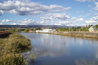
North Esk River
| North Esk River | ||
|
North Esk River in Launceston |
||
| Data | ||
| location | Tasmania ( Australia ) | |
| River system | Tamar River | |
| Drain over | Tamar River → Bass Strait | |
| source | Ben Nevis (North Esk Forest Reserve) 41 ° 22 ′ 5 ″ S , 147 ° 38 ′ 11 ″ E |
|
| Source height | 547 m | |
| muzzle |
Tamar River in Launceston Coordinates: 41 ° 26 ′ 5 " S , 147 ° 7 ′ 40" E 41 ° 26 ′ 5 " S , 147 ° 7 ′ 40" E |
|
| Mouth height | 0 m | |
| Height difference | 547 m | |
| Bottom slope | 6.3 ‰ | |
| length | 86.2 km | |
| Left tributaries | Ford River , Pig Run Creek, River O'Plain Creek, Tea Tree Creek, Rose Rivulet | |
| Right tributaries | Becket Creek, Burns Creek, Musselboro Creek, Weavers Creek, St. Patricks River | |
| Big cities | Launceston | |
| Small towns | Upper Blessington | |
| Communities | Whisloca, White Hills, Corra Linn | |
The North Esk River is a river in the northeast of the Australian state of Tasmania .
geography
River course
The river has its source in the Northallerton Valley on the northern slopes of Ben Nevis , a mountain in the North Esk Forest Reserve , about 38 km east of Launceston . From there it first flows southwest to the small town of Upper Blessington . There it turns its course to the west and flows through the White Hills settlement southeast of Launceston. From there it flows through the southeastern outskirts of the city and forms the Tamar River in the city center together with the South Esk River .
On its way through the city, it flows through the Old Seaport, a former port facility that is now a tourist attraction. The river estuary begins below the Hoblers Bridge . The North Esk River often floods the eastern suburbs of Launceston.
Tributaries with mouth heights
- Beckett Creek - 447 m
- Ford River - 399 m
- Pig Run Creek - 377 m
- River O'Plain Creek - 371 m
- Burns Creek - 359 m
- Musselboro Creek - 353 m
- Weavers Creek - 296 m
- St. Patricks River - 217 m
- Tea Tree Creek - 186 m
- Rose Rivulet - 23 m
history
The history of the North Esk River is almost forgotten. The east and west banks used to be teeming with bush thieves and Aborigines who continually attacked the settlers in the area.
Further upstream, at the first appreciable bend in the river, the Vermont Bend is, there used to be a punt, could sit with you over the river before 1829 in today's district St. Leonards of George Hobler of 'Killafaddy' 'the Hoblers Bridge built has been.
The North Esk area was also previously an electoral district. Many well-known “gentleman farmers” lived on the river over time. Some properties of historical importance can still be found on its banks today, such as B. Breaemar and Vermont just outside of Launceston.
Until the early 1850s, prisoners had to drain the floodplains after they had been cultivated so that they would not become swampy again.
The North Esk River was also where Launceston's main docks were located until the bridge on Charles Street was built. On the south bank between the Old Seaport and the Victoria Bridge (at the south end of Invermay Road ) there were several quays whose history could be traced back to the time of the first settlement by the Europeans. These quays were used by flour mills, breweries, wool merchants, and the Mount Mischoff Tin Smelter (a tin smelter ). Opposite, on the north bank, there were other wharfs accessible from Lindsay Street . There was a loading crane running on rails that could also load and unload entire railway wagons. Further up the river were smaller quays; the one furthest up the river was Dynamite Wharf for the ammunition dump on Glebe Flats .
Web links
Individual evidence
- ↑ a b c d Map of North Esk River, TAS . Bonzle.com
- ^ Steve Parish: Australian Touring Atlas . Steve Parish Publishing, Archerfield QLD 2007. ISBN 978-1-74193-232-4 . Pp. 55 + 61
