Boisa
| Boisa / Aris Island | ||
|---|---|---|
| LANDSAT image by Boisa | ||
| Waters | Bismarcksee | |
| Geographical location | 3 ° 59 '45 " S , 144 ° 57' 50" E | |
|
|
||
| length | 1.61 km | |
| width | 1.27 km | |
| surface | 1.29 km² | |
| Highest elevation | 215 m | |
| Residents | 461 (2000) 357 inhabitants / km² |
|
| main place | Boisa | |
|
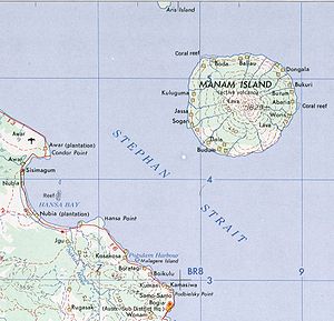
Aris Island in the far north, at the top of the map (part) |
||
Boisa , also called Aris Island , is an island in the Bismarck Sea , located 17 kilometers off the northeast coast of the island of New Guinea and 5.6 kilometers northwest of the island of Manam . The island has a size of 1.29 km² (129 hectares ). According to the 2000 census, a population of 461 was found. The only village is in the west of the island.
Boisa is of volcanic origin, the volcanic cone reaches a height of 215 meters and is flattened at the top.
The island belongs to the Bogia District of the Madang Province of Papua New Guinea .
On Boisa, some of the Manam residents were evacuated in 2004 when the volcano erupted on the neighboring island.
administration
Like the much larger neighboring island of Manam, Boisa belongs to the Bogia District in the north of the Madang Province . Manam and Boisa together form the Iabu Rural LLG (Local Level Government) Area . Boisa forms one of the 15 wards (statistical counting districts) of the LLG, while the other 14 are on Manam.
Web links
Boisa the Global Volcanism Program of the Smithsonian Institution (English)
Individual evidence
- ↑ PNAS Islands Database , there under Aris Island
- ^ Census Unit Register, Madang Province
- ↑ Sailing Directions Pub. 164: New Guinea (PDF; 4.4 MB), there under Aris Island
- ↑ Archive link ( Memento of the original from March 4, 2016 in the Internet Archive ) Info: The archive link was inserted automatically and has not yet been checked. Please check the original and archive link according to the instructions and then remove this notice.
- ↑ District map of the province of Madang ( page no longer available , search in web archives ) Info: The link was automatically marked as defective. Please check the link according to the instructions and then remove this notice.
- ↑ Madang Province ( Memento of the original from October 30, 2012 in the Internet Archive ) Info: The archive link was inserted automatically and has not yet been checked. Please check the original and archive link according to the instructions and then remove this notice. (Boiga District: p. 3; PDF; 167 kB)
- ^ Fisheries Management Act 1998. The National Beche-de-mer Fishery Management Plan


