Manam
| Manam | ||
|---|---|---|
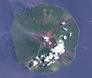
| NASA satellite image of Manam | ||
| Waters | Bismarcksee | |
| Geographical location | 4 ° 5 ′ S , 145 ° 2 ′ E | |
|
|
||
| length | 10.5 km | |
| width | 10.3 km | |
| surface | 83 km² | |
| Highest elevation | Manam volcano 1807 m |
|
| Residents | 10,677 (2005) 129 inhabitants / km² |
|
| main place | Baliau | |
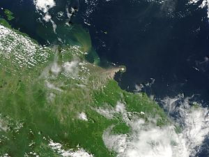
| Ash cloud from Manam volcano, November 2004 | ||
Manam , called Manam Motu by locals , is an inhabited island in the Bismarck Sea and separated from the north coast of New Guinea by the Stephan Strait .
geography
The distance to Hansa Point is 13.3 km. The island with its almost circular plan has a diameter of a good 10 km. It owes its existence to the activity of the Manam Volcano , one of the most active volcanoes in Papua New Guinea. Before the last volcanic eruption, the island could be reached by boat from the coastal town of Bogia, 18 km further south .
In 2005 Manam had a population of 10,677 in 1,880 families or 16 villages. The largest villages on the island are Baliau (north), Dugulaba (also Dukulawa, in the southeast) and Kuluguma (west).
administration
Manam is part of the Bogia District in the north of Madang Province . Together with the small island Boisa (Aris) located four kilometers to the northwest, Manam forms the Iabu Rural LLG (Local Level Government) Area , with the wards (statistical counting districts) named after villages (clockwise, starting in the north, population 2000 census):
![]() Map with all coordinates: OSM | WikiMap
Map with all coordinates: OSM | WikiMap
| No. | Ward | population | Coordinates |
|---|---|---|---|
| 01 | Baliau | 1383 | 4,036 ° S , 145.0326 ° O |
| 02 | Dangale | 425 | 4.0489 ° S , 145.0643 ° O |
| 03 | Kolang | 379 | 4.0552 ° S , 145.0703 ° O |
| 04 | Bikure | 338 | 4.06 ° S , 145.0714 ° O |
| 05 | Abaria | 320 | 4.0663 ° S , 145.0769 ° O |
| 06 | Warisi | 193 | 4.0927 ° S , 145.0683 ° O |
| 07 | Dugulaba | 980 | 4.1202 ° S , 145.0227 ° O |
| 08 | Budua | 14th | 4.1198 ° S , 145.0192 ° O |
| 09 | Madauri | 391 | 4.1167 ° S , 145.0167 ° O |
| 10 | Waia | 309 | 4.1108 ° S , 145.0072 ° O |
| 11 | Zogari | 637 | 4.1088 ° S , 145.0024 ° O |
| 12 | Iassa | 531 | 4.0982 ° S , 144.9979 ° O |
| 13 | Kuluguma | 758 | 4.0752 ° S , 144.9931 ° O |
| 14th | Boda | 761 | 4.0453 ° S , 145.0074 ° O |
| 15th | Boisa | 461 | 3.9961 ° S , 144.9656 ° O |
geology
Manam is a basaltic-andesitic stratovolcano that, despite its extremely symmetrical lower mountain flanks, divides the island into four valleys. These are also known as "avalanche valleys", as pyroclastic currents can arise in these during eruptions . Because of this, these valleys are highly endangered areas during eruptions that are evacuated first of all. The first reports of a volcanic eruption of Manam date from 1616.
Eruptions and dangers
Thirteen residents were killed in an eruption on December 3, 1996 when pyroclastic currents reached the settlement of Budua (Bodua) on the south coast.
In November 2004, over 9,000 islanders were evacuated due to a major volcanic eruption. The outbreak began on October 24, but was not initially seen as a major threat. This changed when the wind changed direction and ash rained on populated areas. Five people were killed.
Illustrations
Sulfur dioxide cloud, released on January 27, 2005 during an eruption of Manam, measured by the OMI (Ozone Monitoring Instrument) on board NASA's Aura satellite
Individual evidence
- ↑ PAPUA NEW GUINEA: MANAM VOLCANO. April 5, 2005 (PDF; 55 kB)
- ↑ ANGRY VOLCANO A FACT OF LIFE ON PNG'S MANAM ISLAND ( page no longer available , search in web archives ) Info: The link was automatically marked as defective. Please check the link according to the instructions and then remove this notice.
- ↑ District map of the province of Madang ( page no longer available , search in web archives ) Info: The link was automatically marked as defective. Please check the link according to the instructions and then remove this notice.
- ↑ Madang Province ( Memento of the original from October 30, 2012 in the Internet Archive ) Info: The archive link was inserted automatically and has not yet been checked. Please check the original and archive link according to the instructions and then remove this notice. (Boiga District: p. 3; PDF; 167 kB)
- ^ Fisheries Management Act 1998. The National Beche-de-mer Fishery Management Plan
Web links
- Manam in the Global Volcanism Program of the Smithsonian Institution (English)
- Map section from 1942


