Bosch (island)
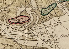
Bosch was a sunken island in the Dutch Wadden Sea in the 18th century , located between Schiermonnikoog and Rottumeroog . According to old maps, Bosch was separated from Schiermonnikoog to the west by a fairway called De Lauwers . To the east was the De Schille water arm , which separated Bosch from Rottumeroog.
history
Until 1530 the island was owned by the Aduard Monastery . There was a village on the island called Cornsant. The All Saints Flood in 1570 washed away large parts of the island, making Bosch uninhabitable. A few decades later, the island began to grow again due to sand washes, but during the Christmas flood in 1717 Bosch finally disappeared into the sea.
Schiermonnikoog was about ten kilometers away from Bosch in 1570 . However, due to constant washings of sand, the island has grown further and further east in the following centuries, so that the eastern tip of Schiermonnikoog is now where the western part of Bosch used to be.
Coastal archaeological research
In spring 2006, a scientific expedition commissioned by the Groninger Museum and the “Stichting Verdronken Geschiedenis” (Stichting Verdronken Geschiedenis) searched for the remains of the former village of Cornsant on the eastern tip of Schiermonnikoog. During measurements with ground penetrating radar , structures were recorded at a depth of three to five meters, which indicate the presence of objects hidden in the ground.
A further investigation in March 2008 revealed evidence of settlement remains in the dune area at the eastern tip of Schiermonnikoog.
Exhibitions about the history of Bosch Island and the search for the remains of the village of Cornsant were shown in 2006 in the open-air museum "Het Hoogeland" in Warffum and in 2008 in the visitor center in Schiermonnikoog.
Fiction
The novel Stormvloed by the Dutch author Ynskje Penning takes place during the sinking of the island Bosch in the All Saints flood in 1570 and relates these events to the Dutch war of independence against Spanish rule, which was just beginning at the time .
Individual evidence
- ↑ Op zoek naar het verdwenen Eiland Bosch ( Memento of the original dated November 29, 2014 in the Internet Archive ) Info: The archive link was inserted automatically and has not yet been checked. Please check the original and archive link according to the instructions and then remove this notice. Report on the search for the remains of Cornsant (Dutch)
- ↑ wetenschappers op zoek naar verdwenen eiland Bosch ( Memento of the original from November 29, 2014 in the Internet Archive ) Info: The archive link was inserted automatically and has not yet been checked. Please check the original and archive link according to the instructions and then remove this notice. Report on the search for the remains of Cornsant (Dutch)
- ↑ Sporen gevonden van verdwenen waddeneiland ( Memento of the original dated November 29, 2014 in the Internet Archive ) Info: The archive link was inserted automatically and has not yet been checked. Please check the original and archive link according to the instructions and then remove this notice. Article (Dutch)
- ↑ Stormvloed: de spectaculaire ondergang van het Waddeneiland Bosch in het begin van de 80-jarige oorlog , Y. Penning, 2007, Uitgeverij Friese Pers / Noordboek, ISBN 90-3300-566-2
Web links
- Foundation "Sunken History"
- Nieuwsuur: Verdronken eiland gevonden (Dutch)
- Map from 1936 with the Boschplaat
Coordinates: 53 ° 30 ′ 35 " N , 6 ° 23 ′ 38" E

