Brabazon Range
| Brabazon Range | ||
|---|---|---|
|
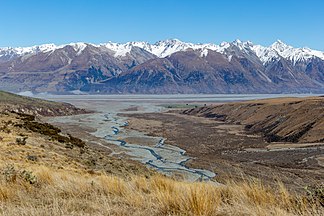
View to the west of the confluence of the Potts River and |
||
| Highest peak | Mount Brabazon ( 1792 m ) | |
| location | Canterbury , South Island , New Zealand ; Timaru District | |
|
|
||
| Coordinates | 43 ° 44 ′ 0 ″ S , 170 ° 53 ′ 0 ″ E | |
| Type | Fold Mountains | |
| surface | 30 km² | |
The Brabazon Range is a mountain range in the Canterbury region of the South Island of New Zealand .
geography
The Brabazon Range is located between the Two Thumb Range , which runs to the east, and the valley of the Rangitata River to the west . The Black Mountain Range borders in the north and the Sinclair Range in the south and part of the Butler Downs plain in the southeast .
The mountain range, which is around 8 km long and runs in an east-west direction, which is accompanied in the north by Black Birch Creek and in the south by the Busch Stream , does not exceed 1,800 m with its peaks . The namesake of the mountain range, Mount Brabazon , has a height of 1792 m .
Through the valley of Busch streams of the valley of runs Rangitata River beginning Busch Stream track in a westerly direction to the heights of Range Two Thumb .
Administratively, the Brabazon Range belongs to the Timaru District .
Conservation Park
The Brabazon Range and the surrounding mountain ranges are part of the Te Kahui Kaupeka Conservation Park , which is administered by the Department of Conservation .
literature
- New Zealand Touring Atlas . 5th edition. Hema Maps , Brisbane 2015, ISBN 978-1-877302-92-3 (English).
Individual evidence
- ↑ Topo maps . Land Information New Zealand , accessed January 28, 2020 .
- ↑ Coordinates and longitudes were determined using Goggle Earth Pro Version 7.3.2.5776 on January 28, 2020
- ↑ a b Brabazon Range, Canterbury . In: NZ Topo Map . Gavin Harriss , accessed January 28, 2020 .
- ↑ Postcode maps . New Zealand Post , accessed January 28, 2020 .
- ↑ Te Kabui Kaupeka Conservation Park . (PDF; 1.4 MB) Department of Conservation , May 2014, accessed on January 28, 2020 .

