Two Thumb Range
|
Two Thumb Range
Te Aruhe Pora
|
||
|---|---|---|
|
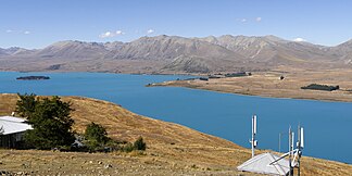
View from Mount John to the northeast to the southern part of the Two Thumb Range |
||
| Highest peak | The Thumbs ( 2545 m ) | |
| location | Canterbury , South Island , New Zealand ; Mackenzie District , Timaru District | |
|
|
||
| Coordinates | 43 ° 51 ′ S , 170 ° 43 ′ E | |
| Type | Fold Mountains | |
The Two Thumb Range , called Te Aruhe Pora in Māori , is a mountain range in the Canterbury region on the South Island of New Zealand .
geography
The Two Thumb Range , which extends over 70 km in a north-south direction, is located east and northeast of Lake Tekapo and west of the two rivers Havelock River and Rangitata River . In the north, the mountain range borders the glaciers of the New Zealand Alps and is flanked in the north by the Sibbald Range to the west and the Cloudy Peak Range to the east . To the south the heights run, separated by the New Zealand State Highway 8 to the Rollesby Range and the Albury Range . Between the Two Thumb Range and Lake Tekapo the Richmond Range can be found and a little further northeast on the east side the Sherwood Range , followed by the Ben McLeod Range and the Sinclair Range .
Numerous peaks of the mountain range have a height of over 2000 m . Of them, The Thumbs is the highest at 2545 m . While on the western slopes next to the Coal River and the Macaulay River numerous streams to Lake Tekapo fill and some southern streams the Grays River carry their waters, rises south of Mount Musgrave of flowing eastward South Opuha River .
Administratively, the Two Thumb Range belongs to the Mackenzie District and Timaru District .
Conservation Park
The entire northern and central part of the Two Thumb Range and around half of the southern part belong to the Te Kahui Kaupeka Conservation Park and are administered by the Department of Conservation .
literature
- New Zealand Touring Atlas . 5th edition. Hema Maps , Brisbane 2015, ISBN 978-1-877302-92-3 (English).
Individual evidence
- ↑ Coordinates and longitudes were determined using Goggle Earth Pro Version 7.3.2.5776 on January 27, 2020
- ↑ a b Topo maps . Land Information New Zealand , accessed January 27, 2020 .
- ↑ Postcode maps . New Zealand Post , accessed January 27, 2020 .
- ↑ Te Kabui Kaupeka Conservation Park . (PDF; 1.4 MB) Department of Conservation , May 2014, accessed on January 28, 2020 .

