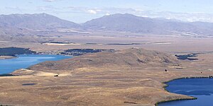
Mount John
| Mount John | ||
|---|---|---|
|
Mount John (in the foreground) |
||
| height | 1031 m | |
| location | on Lake Tekapo , Mackenzie District , Canterbury Region , New Zealand | |
| Coordinates | 43 ° 59 '12 " S , 170 ° 29' 54" E | |
|
|
||
| Normal way | west of Lake Tekapo , an asphalt road leads from New Zealand State Highway 8 to the mountain. The road to the summit is toll. | |
| particularities | On the mountain is the University of Canterbury's Mt John University Observatory | |
The Mount John is a 1031 m high mountain in the Mackenzie District of the Region Canterbury on the South Island of New Zealand .
geography
The Mount John is located at the southwestern end of Lake Tekapo from Lake Alexandrina in the north and the New Zealand State Highway 8 in the south. The mountain has a southwest orientation, is around 4 km long and a maximum of 1.25 km wide and flattens from its maximum height of 1031 m to the northeast. The mountain and its summit are accessible from the state highway .
Mt John University Observatory
On the plateau of the summit is the University of Canterbury's Mt John University Observatory and a cafe for visitors. From the plateau you have a 360 degree view of the New Zealand Alps and the two lakes Lake Tekapo and Lake Alexandrina in the north, the Two Thumb Range in the northeast and east, the wide plain of Irishman Creek with its many parallel streams in the neighborhood and its wetlands in the west and the wide plain and valley of the Tekapo River .
Web links
- University of Canterbury's Mt John Observatory . University of Canterbury,accessed February 18, 2017.
- Facilities at University of Canterbury Mt John observatory . University of Canterbury ,accessed February 18, 2017.
Individual evidence
- ↑ On a map on the plateau, which shows the geographical location of all directions visible from the mountain, the mountain is given at an altitude of 1031 m (see photo), the University of Canterbury gives the mountain at 1029 m .
- ↑ Coordinates and longitudes of the mountain were determined by Google Earth .
- ↑ a b c Topo250 maps - East Coast - Timaru . Land Information New Zealand , accessed February 18, 2017 .


