Rangitata River
| Rangitata River | ||
|
Looking north towards the river (from the bridge near the settlement of Arundel) |
||
| Data | ||
| location | Canterbury , South Island , New Zealand | |
| River system | Rangitata River | |
| confluence |
Havelock River and Clyde River 43 ° 31 ′ 38 ″ S , 170 ° 50 ′ 3 ″ E |
|
| Source height | 570 m | |
| muzzle | 30 km northeast of Timaru in the Pacific Ocean Coordinates: 44 ° 11 ′ 17 " S , 171 ° 30 ′ 34" E, 44 ° 11 ′ 17 " S , 171 ° 30 ′ 34" E |
|
| Mouth height | 0 m | |
| Height difference | 570 m | |
| Bottom slope | 5.6 ‰ | |
| length | 101 km | |
| Catchment area | 1773 km² | |
| Left tributaries | Potts River | |
|
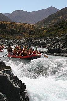
Rafting on the river |
||
The Rangitata River is a river in the Canterbury region of the South Island of New Zealand .
geography
The Rangitata River is formed a good 25 km south of the glacier regions of the New Zealand Alps and around 40 km northeast of Lake Tekapo by the confluence of the Havelock River and Clyde River . After traveling south-southeast and southeast and passing Rangitata Gorge , the river reaches the great plain of the Canterbury Plains after 42 km south of the Moorhouse Range and east of the Tara Haoa Range . From there, the Rangitata River initially flows around 10 km in a southerly direction and, on its way further south-southeast, widens its river bed steadily to a maximum width of 1.5 km in places. After a total of 101 km, the Rangitata River , which has a water catchment area of 1773 km², finally flows into the Pacific Ocean 36 km southwest of Ashburton and around 30 km northeast of Timaru .
17 km north-northwest of the mouth of the Rangitata River , the New Zealand State Highway 1 and the South Island Main Trunk Railway cross the river over two separated bridges over 700 m long.
Water use
Shortly after its entry into the Canterbury Plains , water is taken from the Rangitata River and fed to the Rakaia River via the Rangitata Diversion Race , an approximately 67 km long canal, after it has been used to generate electricity . On the long way of the canal, which runs across the Canterbury Plains , this crosses under the Hinds River South Branch , the Hinds River North Branch , the South Branch Ashburton River , the Taylors Stream and the North Branch Ashburton River .
Movie set
Around 4 km southeast of the confluence of the Havelock River and Clyde River is the small, 2 km long and 611 m high mount of Mount Sunday in the valley of the Rangitata River . The mountain and its surroundings served as a film set for Edoras in the film The Two Towers of the trilogy The Lord of the Rings .
Recreational sports
With an average water throughput of around 100 m³ / sec. salmon and trout can be fished very well in the Rangitata River . The best fishing results can be achieved with a water flow of 80 to 110 m³ / sec. and a slight coloration of the water can be expected.
The white water - rafting on the river is possible. In the area of the Rangitata Gorge a level of difficulty 5 can be expected for navigating the river, further down the river the level of difficulty is given as 2.
Water protection
On December 23, 1999, Fish and Game New Zealand applied for a Water Conservation Order for the river. This was granted and put into effect on June 19, 2006 with the Water Conservation ( Rangitata River ) Order .
Web links
Individual evidence
- ↑ a b c Rangitata River, Canterbury . In: NZ Topo Map . Gavin Harriss , accessed January 30, 2020 .
- ↑ a b Coordinates and longitudes were determined using Goggle Earth Pro Version 7.3.2.5776 on January 30, 2020
- ↑ a b Rangitata River . Land Air Water Aotearoa , accessed January 30, 2020 .
- ↑ a b Topo maps . Land Information New Zealand , accessed January 30, 2020 .
- ↑ Mount Sunday Track . Deportment of Conservation , accessed January 30, 2020 .
- ^ Rangitata River . (PDF; 1.9 MB) Fish & Game , accessed on January 30, 2020 (English).
- ↑ Homepage . Rangitata Rafts , accessed January 30, 2020 .
- ^ Application for a Water Conservation Order on the Rangitata River . Ministry for Environment , archived from the original on September 27, 2007 ; accessed on January 30, 2020 (English, original website no longer available).
- ^ Water Conservation ( Rangitata River ) Order . (PDF; 963 kB) Department of Internal Affairs , accessed January 30, 2020 (English).

