Rakaia River
| Rakaia River | ||
|
Rakaia River system |
||
| Data | ||
| location | Canterbury Plains , Canterbury Region , South Island (New Zealand) | |
| River system | Rakaia River | |
| origin | Glacier lake at the end of Lyell Glacier 43 ° 18 ′ 12 ″ S , 170 ° 53 ′ 22 ″ E |
|
| muzzle | Over the Rakaia Lagoon in the Pacific Coordinates: 43 ° 53 '41 " S , 172 ° 13' 36" E 43 ° 53 '41 " S , 172 ° 13' 36" E
|
|
| length | 150 km | |
| Drain |
MNQ MQ |
87 m³ / s 203 m³ / s |
| Left tributaries | Mathias River , Wilberforce River , Acheron River | |
| Small towns | Rakaia | |
|
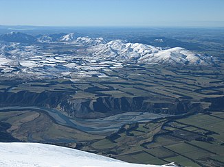
Rakaia River as seen from Mount Hutt |
||
|
The bridge over the Rakaia Gorge |
||
|
Rakaia River, aerial view |
||
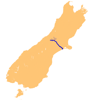
The Rakaia River is a river in the Canterbury Plains on the South Island of New Zealand . It is one of the largest intertwined rivers in New Zealand. The river has an average discharge of 203 m³ / s and an annual minimum of 87 m³ / s averaged over seven days.
The river has its source in the Southern Alps and then runs 150 km essentially in an easterly and south-easterly direction. It flows into the Pacific 50 km south of Christchurch .
For a large part of its course, the river is an intertwined river that flows on a wide gravel bed. Near Mount Hutt , it is briefly narrowed in a canyon, the Rakaia Gorge .
In the 1870s there were plans to extend the Whitecliffs Branch branch line through Rakaia Gorge. In 1880 the Royal Commission for Rail Transport voted in favor of the plan, but it was never implemented. In 1882 a road bridge was opened over the gorge.
There are two bridges over the lower reaches of the river in the village of Rakaia , which are the longest road and rail bridges in New Zealand. They are a little over 1750 m long. The village of Rakaia is 12 miles from the estuary, about halfway between Christchurch and Ashburton .
The river is known for fishing for king salmon ( Oncorhynchus tshawytscha ).
The Rakaia river basin is home to 73% of the total population of the plover Anarhynchus frontalis, known in New Zealand as "Wrybill" or "Ngutuparore" . Other bird species are the black-fronted tern ( Chlidonias albostriatus ) and the double-banded plover ( Charadrius bicinctus ).
The Central Plains Water Trust wants to take up to 40 m³ / s of water from the river.
Web links
- Richard: Salmon on the Rakaia River. Scale-Tales, June 18, 2007, archived from the original on September 29, 2007 ; accessed on September 7, 2014 (English, original website no longer available).
Individual evidence
- ^ A b M. Morgan, V. Bidwell, J. Bright, I. McIndoe, C. Robb: Lincoln Environmental Report No 4557/1 . Ed .: Lincoln University. Lincoln 2002 (English). Online: Canterbury Strategic Water Study. Environment Canterbury, 2006, archived from the original on May 20, 2007 ; accessed on September 7, 2014 (English, original website no longer available).
- ^ Morland, K. 1994: Water Resources of the Canterbury Region. Canterbury Regional Council Unpublished Technical Report U94 / 59.
- ^ The Rakaia River. Selwyn District Council, archived from the original on September 28, 2007 ; accessed on September 7, 2014 (English, original website no longer available).
- ↑ West IF and Goode, RH (1987) "Aerial counts of spawning chinook salmon (Oncorhynchus tshawytscha) on the Rakaia River system, Canterbury, New Zealand, 1973-76." New Zealand Journal of Marine and Freshwater Research, 1987, Vol. 21: 563-572.
- ^ O'Donnell, CFJ (2000). The significance of river and open water habitats for indigenous birds in Canterbury, New Zealand, Environment Canterbury Unpublished Report U00 / 37.
- ^ Central Plains Water Trust. Environment Canterbury, archived from the original on March 15, 2007 ; accessed on September 7, 2014 (English, original website no longer available).


