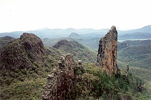
Breadknife
| Breadknife | ||
|---|---|---|
|
Breadknife in the foreground |
||
| location | New South Wales , Australia | |
| Coordinates | 30 ° 3 ′ 0 ″ S , 150 ° 3 ′ 0 ″ E | |
|
|
||
| Type | volcanic rock dike | |
The Bread Knife ( bread knife ) is a volcanic dyke from Trachyt in northern New South Wales in Australia . The rock dike in Warrumbungle National Park , which was formed in the Miocene , reaches a height of almost 100 m, is several meters wide and about 600 m long. Such a geological formation is very rare. The closest place is Coonabarabran, 30 km away .
The Breadknife is part of an active shield volcano that erupted 17 to 13 million years ago. This volcano formed the Warrumbungle Range , which was about 1000 m high and is now largely eroded. The breadknife was formed by glowing magma that solidified in soft rock and formed a harder and more permanent layer than the surrounding rock. When the soft rock weathered , the basalt breadknife was exposed.
A hiking path leads to the Breadknife from the Pincham parking lot along Pirey Creek, which takes about five hours and makes the ascent to the base of the mountain even easier with paved climbing aids. Hiking to this well-known mountain in Australia is very popular, but climbing is prohibited.
Other mountains such as Crater Bluff , Bluff Mountain , Belougery Spire and Balor Peak are nearby .
Web links
- yktravelphoto.com : Pictures of the Breadknife
Individual evidence
- ↑ vnc.qld.edu.au ( Memento of the original from November 20, 2011 in the Internet Archive ) Info: The archive link was inserted automatically and has not yet been checked. Please check the original and archive link according to the instructions and then remove this notice. : ROCK LANDFORMS of Australia & New Zealand, accessed December 12, 2012
- ↑ a b environment.nsw.gov.au : Warrumbungle National Park. Breadkniefe and Grand Hig Tops , in English, accessed December 11, 2012

