Brisbane Heights
| Brisbane Heights | ||
|---|---|---|
|
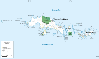
Map of Coronation Island (center) with Brisbane Heights |
||
| location | Coronation Island , South Orkney Islands | |
|
|
||
| Coordinates | 60 ° 36 ′ S , 45 ° 38 ′ W | |
The Brisbane Heights are a series of hills up to 960 m high in the center of Coronation Island in the archipelago of the South Orkney Islands . They arcuate from Worswick Hill to the High Stile Mountain Pass .
The Falkland Islands Dependencies Survey carried out the naming following a survey lasting from 1948 to 1949. However, the name Brisbane Plateau was changed to the current form after a 1956 survey. It is named after the British captain Matthew Brisbane (1787-1833), who reached the South Orkney Islands together with James Weddell in January 1823 and roughly mapped the coastline of the southern section of the archipelago.
Web links
- Brisbane Heights in the Geographic Names Information System of the United States Geological Survey (English)
- Brisbane Heights on geographic.org (English)

