Coronation Island
| Coronation Island | ||
|---|---|---|
| Tourists on Coronation Island between penguins | ||
| Waters | Southern ocean | |
| Archipelago | South Orkney Islands | |
| Geographical location | 60 ° 35 ′ S , 45 ° 38 ′ W | |
|
|
||
| length | 40 km | |
| width | 13 km | |
| surface | 457 km² | |
| Highest elevation |
Mount Nivea 1265 m |
|
| Residents | uninhabited | |
| main place | Sandefjord Bay (historic) | |
| Location of Coronation Island (center) in the archipelago of the South Orkney Islands | ||
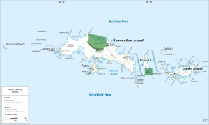
Coronation Island (sometimes Germanized as Coronation Island ) is an island belonging to the Southern Orkney Islands in the Southern Ocean . It is located just inside the territory protected by the Antarctic Treaty .
The island is approximately 40 km long, between 5 and 13 km wide and with an area of 450 km² the largest of the South Orkney Islands. About 85% of it is glaciated and in Mount Nivea it reaches a height of up to 1,265 m above sea level.
The island was discovered in December 1821 by the American seal hunter Nathaniel Palmer and the British captain George Powell (1794-1824). Powell honored with the name Coronation ( Coronation ) its rulers George IV. , The 1821 King of Britain was crowned.
The British shelter Sandefjord Bay on the western tip of the island was built on gravel on February 12, 1945. In 1956 it was canceled.
Individual evidence
- ↑ UNEP Islands Directory (English)
- ↑ Mount Nivea on Peakbagger.com (English)
- ↑ Antarctic stations on scattered islands
Web links
- Coronation Island in the Geographic Names Information System of the United States Geological Survey (English)
- Coronation Island on geographic.org (English)


