
Buaya
| Buaya | ||
|---|---|---|
 |
||
| Waters | Lake Flores | |
| Archipelago | Alor archipelago | |
| Geographical location | 8 ° 10 '34 " S , 124 ° 22' 25" O | |
|
||
| length | 2.8 km | |
| width | 2 km | |
| surface | 3.74 km² | |
| Residents | 1171 (2010) 313 inhabitants / km² |
|

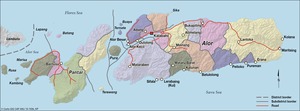
Buaya ( Indonesian for crocodile , formerly Kisu ) is an Indonesian island in the Alor archipelago .
geography
The island is located at the northern end of the Pantar Strait in the Flores Sea between the islands of Alor and Pantar . It belongs to the district of West Alor Meer (Alor Barat Laut). Here it forms an administrative village (Desa) with 1,171 inhabitants (2010).
Individual evidence
- ↑ card Lomblens
- ↑ Map of the Alor Archipelago
- ^ Administrative map of the Alor archipelago
- ↑ List of the administrative units of Indonesia down to the Desas 2010 ( Memento from April 6, 2013 in the Internet Archive ) (English; PDF; 5.9 MB)