
Pura (island)
| Pulau Pura | ||
|---|---|---|
 |
||
| Waters | Lake Flores , Lake Sawu | |
| Archipelago | Alor archipelago | |
| Geographical location | 8 ° 17 '54 " S , 124 ° 20' 46" E | |
|
||
| length | 6.7 km | |
| width | 6 km | |
| surface | 27.53 km² | |
| Highest elevation | Pura 1015 m |
|
| Residents | 1945 (2010) 71 inhabitants / km² |
|
| main place | Pura | |

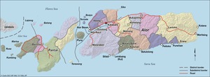
Pulau Pura is an island in the Alor Archipelago in Indonesia .
geography
The island is located in the Pantar Strait between the islands of Alor and Pantar . Pura has an area of 27.53 km² and reaches an altitude of 1015 meters. It forms a district in Kabupaten Alor .
Overview of the villages:
| Desa / Kelurahan | population |
|---|---|
| Pura Barat | 156 |
| Pura Selatan | 166 |
| Maru | 111 |
| Pura Timur | 120 |
| Pura | 1,196 |
| Pura Utara | 196 |
Individual evidence

Kabola | Lembur | Mataru | North Central Alor ( Alor Tengah Utara ) | East Alor ( Alor Timur ) | Ostalor Meer ( Alor Timur Laut ) | Eastern pantar ( Pantar Timur ) | Pantar | Pura Island ( Pulau Pura ) | Pureman | South Alor ( Alor Selatan ) | Southwest Alor ( Alor Barat Daya ) | Teluk Mutiara | West Alor Sea ( Alor Barat Laut ) | West Pantar ( Pantar Barat ) | West Pantar Sea ( Pantar Barat Laut ) | Central pantar ( Pantar Tengah )