Bubiyan
| Bubiyan | ||
|---|---|---|
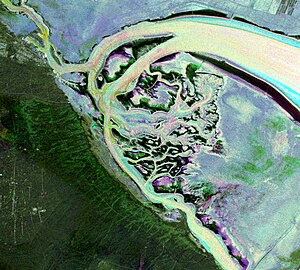
| False color image of the islands of Bubiyan and al-Warba | ||
| Waters | Persian Gulf | |
| Geographical location | 29 ° 44 ' N , 48 ° 12' E | |
|
|
||
| length | 40 km | |
| width | 24 km | |
| surface | 863 km² | |
| Residents | uninhabited | |
| After al-Warba, the northernmost island of Kuwait | ||
Bubiyan ( Arabic جزيرة بوبيان, DMG Ǧazīrat Būbiyān ) is the largest island off the coast of Kuwait with an area of 863 km² . It is located in the northeasternmost area of the Persian Gulf . The flat, inhospitable island is an uninhabited military area. Bubiyan is part of the Kuwaiti governorate of al-Jahra .
Bubiyan is the largest of a group of eight islets in the mouth of the Shatt al-Arab . Between Bubiyan and the Iraqi mainland in the northeast the Chaur Abd Allah /خور عبد الله, between Bubiyan and the Kuwaiti mainland in the southwest of the Chaur as-Sabiya /خور الصبية. The latter channel continues to the north of the island, where it separates Bubiyan from the neighboring island of al-Warba . 5.4 kilometers north of the southernmost point of the island on Ra's al-Barscha, Bubiyan is connected to the Kuwaiti mainland by a 2.38 km long girder bridge .
A port facility with a railway connection is currently being built on the northeast coast of the island, called Mubarak al-Kabir (ميناء مبارك الكبير / Mīnāʾ Mubārak al-Kabīr ). Completion is planned for 2016.
Until 1994, Bubiyan was controversial due to its strategically important location between Kuwait and Iraq . The bridge was badly damaged in the Second Gulf War , but was subsequently restored. In 1994 Iraq approved the UN Security Council's proposal to draw borders .
Web links
- Bubiyan Bridge. In: Structurae
- Bubiyan in the online edition of the Encyclopædia Britannica (English)
- Nautical information (pdf, English; 607 kB)
- Report on the reconstruction of the bridge (English)
- Soviet General Staff Map 1: 200,000, map sheet h-39-19 ( Russian )


