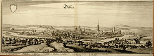
Döbeln Castle

| Döbeln Castle | ||
|---|---|---|
| Alternative name (s): | Doblin Castle | |
| Creation time : | after 929 | |
| Castle type : | Hilltop castle | |
| Conservation status: | Burgstall | |
| Standing position : | Clerical | |
| Place: | Chub | |
| Geographical location | 51 ° 7 '17.1 " N , 13 ° 7' 34.5" E | |
|
|
||
The castle Döbeln earlier castle Doblin called, is an Outbound hilltop castle on a rocky outcrop, the Schlossberg , in the fork of the Freiberger trough on the eastern edge of the city Döbeln in mittelsachsen .
History and layout
The German castle Burg Doblin was built after 929 on an original rampart with a triangular wood-earth wall on an area of about 75 by 50 meters from the Slav period .
The castle was first mentioned in documents in 981, when Otto II gave the castle to the Memleben monastery. The inhabitants had the castrum Doblin , until then a Burgwardum was to lock expand. It was a stone castle since the 13th century.
In the 15th century, the castle lost its importance as the official seat of the city, fell into disrepair and was probably destroyed in the Saxon Civil War in 1450 . The remains of the castle were used as a quarry until the 18th century and were finally removed from 1867 to 1869 for the construction of the Schloßberg School and a gym.
literature
- Carl W. Hingst : Chronicle of Döbeln and the surrounding area . Döbeln 1872, p. 23 ff. ( Online ).
- Ralph Gundram: The Schlossberg and the castle to Döbeln. , In: Monuments in the district of Döbeln, Issue 7, Döbeln 2005
Individual evidence
- ↑ http://www.regionalgeschichte-doebeln.de/HBurgVor.html ( page no longer available , search in web archives ) Info: The link was automatically marked as defective. Please check the link according to the instructions and then remove this notice.
