
Plankenau Castle
.jpg)
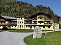
The decrepit Plankenau Castle is located in the municipality of St. Johann im Pongau in the Salzburg district of the same name (near the Schlosshof youth hostel, Liechtensteinklammstrasse 142).
history
Finds of clay pots show that the Burgplatz was inhabited as early as the Bronze Age and the Late Iron Age. The castle itself was first mentioned in a document in 1155; it is likely to have been built in the 10th or 11th century. At that time, Bertold von Pongau donated half of his court to the Salzburg Cathedral Chapter and the other half to Admont Abbey . Also known is a Rüdiger von Plankenau, who was the cupbearer of Archbishop Eberhard I and who died in 1155. In 1372 another Hermann von Plankenau is mentioned. After the male line died out, the Pongau family passed into the Goldegger family through marriage .
- Burgstall Plankenau
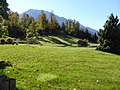
Plankenau castle hill
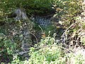
Rising masonry

Collapsed entrance
Access to the Burgstall
.jpg)
.jpg)
.jpg)
.jpg)
Plankenau castle ruins today
On the orographically right bank of the Salzach between Schwarzach and St. Johann are the ruins of Plankenau Castle on a plateau about 30 m above the valley floor. Due to its location, it was able to dominate the Salzach Valley and the entrance to the Grossarl Valley .
A rampart in the form of a dilapidated stone wall surrounds the 80 × 40 m large castle area. On the northeast side there is an additional earth wall, which presumably protected the entrance to the castle. There are remains of a square keep.
The castle hill is criss-crossed by a system of corridors with a total length of 160 m at a depth of about 4 m. These have been hewn out of the conglomerate rock and are as tall as a man. Light niches as well as sleeping and air holes were preserved. Entrances to this were found on the northwest side near the Salzach and on the southeast side inland. These corridors are reminiscent of so-called Erdststall , which are more typical for Upper Austria. The entrance on the salt axis collapsed before the First World War . The other entrance was supported by posts. After the First World War, however, the outermost section of the corridor collapsed and you could only get inside by crawling over the rubble. In the spring of 1931 this last entrance also collapsed, so that these corridors are completely relocated and inaccessible today.
The journey leads through the Jugendhotel Schlosshof; from here you can see the castle hill above a small lake. The access to the former castle is not signposted.
literature
- Friederike Zaisberger & Walter Schlegel : Castles and palaces in Salzburg. Pongau, Pinzgau, Lungau . Birch series, Vienna 1978, ISBN 3-85030-037-4 .
- Lambert Karner : Artificial Caves from Ancient Times, Vienna 1903, reprint 2018, ISBN 978-3-96401-000-1 , pp. 196–197.
Web links
- Plankenau Castle on Salzburgwiki
- Entry on Castle Plankenau in the private database "Alle Burgen".
- Plankenau castle ruins on Wehrbauten.at
Individual evidence
- ↑ Historical overview of Wagrain Castle. (PDF 2.0 MB) Federal Monuments Office , archived from the original on March 5, 2016 ; Retrieved February 3, 2014 .
Coordinates: 47 ° 19 ′ 29 ″ N , 13 ° 11 ′ 2 ″ E