Byewater Point
| Byewater Point | ||
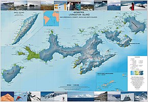
 Byewater Point at the western end of Snow Island (bottom left) |
||
| Geographical location | ||
|
|
||
| Coordinates | 62 ° 45 ′ S , 61 ° 30 ′ W | |
| location | Snow Island , South Shetland Islands | |
| Waters | Drake Street | |
| Waters 2 | Boyd Strait | |
The Byewater Point (formerly Cape Byewater ) is a headland on the west coast of Snow Iceland in the archipelago of the South Shetland Islands .
The British navigator Henry Foster mapped them in January 1829 as part of the research voyage with the HMS Chanticleer (1827-1831). He originally named it Cape Brewster after the Scottish physicist David Brewster (1781–1868). Shortly afterwards, Foster changed the name to Cape Byewater for unknown reasons ; the namesake is not overlaid. Aerial photographs from the Falkland Islands and Dependencies Aerial Survey Expedition (FIDASE, 1956–1957) revealed that it is more of a headland than a cape . The UK Antarctic Place-Names Committee adapted Foster's naming on August 31, 1962 accordingly.
Web links
- Byewater Point in the Geographic Names Information System of the United States Geological Survey (English)
- Byewater Point on geographic.org (English)
