Bynon Hill
| Bynon Hill | ||
|---|---|---|
|
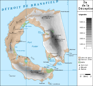
Map of Deception Island with Bynon Hill (here: Colline Goddard ) |
||
| height | 332 m | |
| location | Deception Island , South Shetland Islands | |
| Coordinates | 62 ° 54 ′ 40 " S , 60 ° 35 ′ 21" W | |
|
|
||
The Bynon Hill ( spanish Monte Bynon , also known as Goddard Hill ) is a 332 m high, the icy and dome-shaped hill with two rounded peaks on Deception Iceland in the archipelago of the South Shetland Islands . It rises 2.5 km north of Pendulum Cove .
His Spanish name first appears on an Argentine map from 1956. Presumably namesake is a participant in an Argentine Antarctic expedition that lasted from 1952 to 1953. In the United Kingdom , the hill has been named after midshipman William Henry Goddard († 1849), author of the earliest maps of the South Shetland Islands, since 1957 .
Web links
- Bynon Hill in the Geographic Names Information System of the United States Geological Survey (English)
- Bynon Hill on geographic.org (English)

