
Campos do Jordão
| Campos do Jordão | ||
|---|---|---|
|
Coordinates: 22 ° 44 ′ S , 45 ° 35 ′ W Campos do Jordão on the map of São Paulo
|
||
| Basic data | ||
| Country | Brazil | |
| State | São Paulo | |
| Residents | 47,789 (2010) | |
| City insignia | ||
 |
 |
|
| Detailed data | ||
| surface | 290.520 km² | |
| height | 1628 m | |
| City Presidency | Frederico Guidoni Scaranello ( PSDB ), (2017-2020) | |
| Website | ||
 |
||

Campos do Jordão , officially Portuguese Município da Estância Climática de Campos do Jordão , is a city in the state of São Paulo in Brazil . According to official estimates by the IBGE , around 51,800 people lived here in 2018. The city is located about 170 km northeast of the city of São Paulo , 1,628 meters above sea level in the mountains of the Serra da Mantiqueira . It is the highest municipality in Brazil. A common nickname of the city is Suíça Paulista (in German about: São-Paulosche Schweiz ). It is particularly popular with Brazilian tourists and weekenders from São Paulo in the Brazilian winter who want to experience “European feelings” in the cold season. Then the villas, apartment houses and hotels fill up. This part of Campos do Jordão is almost deserted on weekdays outside the holiday periods.
The place is located in a valley with some half-timbered houses built in the Swiss style . The main attraction, besides the city itself, is the 1,950-meter-high Pedra do Baú (Chest Rock), a granite block with a height of 330 meters, which rises from the landscape from afar. It is on the way to São Bento do Sapucaí .
The urban part of Campos do Jordão stretches for about 5 kilometers in a valley: the Abernéssia commercial center (a phrase that goes back to Aberdeen and Inverness ), Jaguaribe with the bus station and the tourist Capivari , where most of the restaurants, hotels and boutiques are located lie. In addition to city buses, the city districts are connected by a small tram. The train to Santo Antônio do Pinhal , which is mostly used by visitors, runs on the same tracks .
In the higher areas there are many araucarias that still dominate the native vegetation today . The eastern part of the municipality is occupied by the Parque Estadual de Campos do Jordão (also called Horto Florestal ). It can be reached by city bus and, in addition to a good infrastructure, offers around 20 km of hiking trails. You can get a view of the city from the Morro do Elefante (elephant hill). A distant view of the Paraíba valley is from Pico de Itapeva, 15 km away .
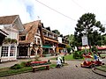
downtown

Granite rock Pedra do Baú


Web links
Individual evidence
- ↑ a b IBGE to Campos do Jordão. Retrieved May 25, 2019 .
- ^ Fred 45 (Prefeito). In: todapolitica.com. Eleições 2016, accessed August 2, 2019 (Brazilian Portuguese).