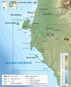
El Boquerón Canal
| El Boquerón Canal | |
|---|---|
| Connects waters | Pacific Ocean |
| with water | Pacific Ocean |
| Separates land mass | Isla San Gallán |
| of land mass | Península de Paracas |
| Data | |
| Geographical location | 13 ° 51 ′ 1 ″ S , 76 ° 25 ′ 2 ″ W |
| Smallest width | 4.5 km |
| Greatest depth | 55 m |
The El Boquerón Canal is a strait on the Peruvian Pacific coast . It separates the Península de Paracas peninsula from the Isla San Gallán to the west . Administratively, the area belongs to the Paracas district of the Pisco province in the Ica region . It is part of the Reserva nacional de Paracas marine reserve .
The strait is 55 meters deep at its deepest point and 4.5 kilometers wide at its narrowest point. An arm of the Humboldt Current flows through it in a south-north direction .
The canal is the easiest access for seagoing ships calling at the General San Martín port. Most of the shipping traffic between Bahía de Pisco and the south also takes this route. Around 1.6 kilometers south of San Gallán, a hard-to-see rock, the Roca Piñeiro, has to be circumnavigated. At times there are strong winds opposite the current, which lead to rough seas and strong tides.
In the northern extension of the canal are the Islas Ballestas .
Individual evidence
- ↑ a b c Dirección de Hidrografía y Navegación de la Marina de Guerra del Perú: Derrotero de la costa del Perú: Volume II Punta Huanchaco a Punta Infiernillos . Edition 2006, p. 120
- ↑ a b National Geospatial-intelligence Agency: Prostar Sailing Directions 2004 West Coast of South America Enroute. ProStar Publications 8th Edition 2004, p. 49, ISBN 1-57785-551-5
