Carretera Nacional NV
| Carretera Nacional NV in Spain | |
| Carretera de Extremadura | |

|
|
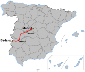
| map | |
| Basic data | |
| Operator: | |
| Start of the street: |
Almaraz ( 39 ° 50 ′ N , 5 ° 40 ′ W ) |
| End of street: |
Badajoz ( 38 ° 53 ′ N , 6 ° 55 ′ W ) |
| Overall length: | 52 km (current) / 407 km (historical) |
|
current: historical: |
|
The Carretera Nacional NV is a national road in Spain . With a total length of 407 kilometers, it was the second shortest of the six national roads starting in a star shape from Madrid and leading to the outer limits of Spain. Today the route only exists on approx. 50 kilometers long sections parallel to the A-5 motorway .
course
The Carretera Nacional NV led from the capital Madrid via Badajoz to the Portuguese border, where it continued on the Portuguese motorway A6 , which was previously signposted as Portuguese national road 4 . This route was established around 1940.
With the exception of a few sections, the national road was completely replaced by the A-5 motorway or expanded to become it. Between Almaraz and Jaraicejo (Sur) as well as Talavera la Real (37.3 km) and Badajoz (14.6 km) the still existing NV runs parallel to the A-5 motorway .
The sections that were not expanded to form the A-5 motorway were rededicated to the Carretera Nacional N-Va . These are the sections at Trujillo , Villamesias and Mérida . These mostly very short stretches were part of the national road NV that ran through these villages. In the course of the A-5 motorway, however, bypasses were built so that the routes through the localities were preserved.
