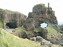
Carsaig Arches
The Carsaig Arches are two rock gates on the south coast of the Isle of Mull, Scotland . They are located about seven kilometers southwest of the small settlement Carsaig on the south bank of the Ross of Mull , the southernmost peninsula of the Isle of Mull.
The rock gates were created by the erosion of sedimentary rock , in particular oolite , on which basalt columns were deposited in this area of the coast . The softer sediments have largely disappeared due to the constant erosion by the Atlantic and have given rise to the arches made of the harder basalt . The eastern arch consists of a longer tunnel under the basalt cliffs, the floor of which is under water at high tide . Behind it is a striking rock tower to the west, the rock gate of which is known as a "keyhole" due to its shape. On top of it is a small rock tower that looks like a chimney .
The arches can be reached via a narrow, partially exposed, approximately seven-kilometer path along the coast. Due to the tides - at high tide the eastern rock gate and the access are flooded - access to the Arches is restricted only at low tide .
Web links
- Directions to the Carsaig Arches (English)
Individual evidence
- ↑ Ferdinand circle : Geological sketches from the west coast of Scotland. In: Journal of the German Geological Society. Vol. 23, No. 1, 1870/1871, ISSN 0012-0189 , pp. 1–124, here p. 53 .
Coordinates: 56 ° 17 '35.1 " N , 6 ° 3' 1.4" W.
