
Castillo de San Pedro de la Roca
| Castillo de San Pedro de la Roca | |
|---|---|
|
UNESCO world heritage |
|

|
|
| Part of the fortifications |
|
| National territory: |
|
| Type: | Culture |
| Criteria : | iv, v |
| Surface: | 93.88 ha |
| Reference No .: | 841 |
| UNESCO region : | Latin America and the Caribbean |
| History of enrollment | |
| Enrollment: | 1997 (session 21) |

The Castillo de San Pedro de la Roca (colloquially also Castillo del Morro - not to be confused with the Castillo de los Tres Reyes del Morro in Havana ) is a fortress on the coast about 10 km southwest of the Cuban city of Santiago de Cuba .
history
The fortress was designed in 1637 by Juan Bautista Antonelli (1585–1649), a Madrid-born descendant of a family of military engineers from Gatteo , Italy. It was designed by the city's governor, Pedro de la Roca y Borja , as a defensive structure against pirate attacks and was intended to replace an earlier, smaller fortification from 1590 to 1610. Some of the parts of this earlier fortification were later incorporated into the new fortress.


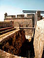
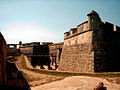
Antonelli's design was adapted to the location of the fortress on the steep flanks of a protrusion reaching into the bay - em morro , after which the fortress is also named. The fortress was built on several terraces. There were 4 main levels and three large bastions for the artillery. Supplies were delivered over the sea and stored in a large warehouse carved directly into the rock or taken to the citadel on the top level. It took 42 years to build the citadel. It began in 1683 and ended with several interruptions in 1700. Antonelli was called back to Cuba in 1645, shortly after the start of the project, to design the two fortresses Fuerte del Cojimar and Fuerte de Santa Doratea de Luna de Chorrera .
The fear of pirate attacks was well founded. In 1662, while the fortress was still under construction, English privateers took control of Santiago for two weeks and during this time destroyed part of the fortification and captured the artillery. After they left Santiago, the Spanish government ordered the rebuilding of the destroyed part of the fortress and reinforced the garrison to 300 men. Between 1663 and 1669, engineers Juan Císcara Ibáñez, Juan Císcara Ramirez and Francisco Pérez repaired the damage and improved the fortifications. They reinforced the flanks and built a new artillery platform.
The fortress prevented the attack of a French flotilla in 1678 and in 1680 repulsed another attack of 800 men under Franquesma , the vice-commander of the filibustier of the Antilles .
Between 1675 and 1692 the fortress was damaged by several earthquakes. In the years 1693 to 1695, therefore, repairs were carried out under Francisco Pérez. Further work was carried out in 1738–1740 by the engineer Antonio de Arredondo , who enlarged the citadel and completed some of the previously unfinished platforms. Juan Martín Cermeño and Francisco Calderín made final changes to the structure after it was again damaged by earthquakes between 1757 and 1766.
In 1775 the fear of pirate attacks had subsided and the parts of the fortress known as "the rock" ( la Roca ) and "the star" ( la Estrella ) were converted into a prison for political prisoners. The rest of the fortress remained a military base.
In 1898 the fortress was used again when the United States' navy attacked Santiago de Cuba during the Spanish-American War .
World Heritage
During the 20th century the fortress fell into disrepair. In the 1960s it was restored under Francisco Prat Puig. The fortress has been accessible as a museum since 1978 and has been an official national monument since 1979. In 1997 the fortress was declared a World Heritage Site by UNESCO under the number 841 . It is considered to be the best preserved and most complete example of Spanish-American military architecture.
Views
Castillo San Pedro de la Roca
Castillo San Pedro de la Roca
Castillo San Pedro de la Roca

Castillo San Pedro de la Roca

Castillo San Pedro de la Roca

Castillo San Pedro de la Roca

Castillo San Pedro de la Roca

Castillo San Pedro de la Roca
Castillo San Pedro de la Roca


Web links
- Entry on the UNESCO World Heritage Center website ( English and French ).
- Josefina Ortega: Castillo de San Pedro de la Roca, el Morro santiaguero: Entre viejas historias y nuevas contiendas , in: La Jiribilla (Spanish)
- Antonio Ramos Zúñiga: The Morro Castle of Santiago de Cuba: A piece of World Heritage. In: Herencia Cultural Cubana , Vol. 16 No. 1, March 2010, pp. 10–13 (English / Spanish)
swell
- World Heritage Site by Unesco: San Pedro de la Roca Castle, Santiago de Cuba . UNESCO. 1997. Retrieved March 1, 2007.
- Rachel Carley: Cuba: 400 Years of Architectural Heritage . Watson-Guptill, 2000, p. 224, ISBN 0-8230-1128-3 .
- René Chartrand: The Spanish Main 1493-1800 . Osprey, 2006, p. 64, ISBN 1-84603-005-6 .
- Castillo de San Pedro de la Roca del Morro ( Spanish ) Consejo Nacional de Patrimonio Cultural. Retrieved December 4, 2013.

Cultural heritage: Old town and fortifications of Havana (1982) | Trinidad and the Valle de los Ingenios (1988) | Castillo de San Pedro de la Roca (1997) | Valle de Viñales Cultural Landscape (1999) | Archaeological landscape of the first coffee plantations in southeastern Cuba (2000) | Historic city center of Cienfuegos (2005) | Historic center of Camagüey (2008)
Natural heritage: Desembarco del Granma National Park (1999) | Alexander von Humboldt National Park (2001)
Coordinates: 19 ° 58 ′ 7 ″ N , 75 ° 52 ′ 12.3 ″ W.