Chang Bhakar
| Chang Bhakar | |||||
| approx. 1790-1948 | |||||
|
|||||
| Capital |
Bharatpur (–1946) Janakpur (1946–1948) |
||||
| Form of government | Princely State | ||||
| surface | 2347 km² | ||||
| population | 19,548 (1901) | ||||
| founding | circa 1790 | ||||
| resolution | January 1, 1948 | ||||
| State religion: Hinduism Dynasty: Chauhan |
|||||
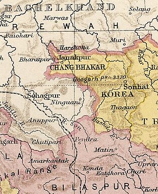
| Map excerpt from The Imperial Gazetteer of India | |||||
Chang Bhakar (also Changbhakar ; capital Bharatpur , from 1946 Janakpur ) was a princely state of British India on the Chota-Nagpur plateau in today's state of Chhattisgarh . The principality of the Chauhan - Rajputs was originally part of Korea , in 1818 the British East India Company made it a separate state under the sovereignty of Korea, and in 1848 an independent British protectorate (until 1947). In 1901 it had an area of 2347 km² and 19,548 inhabitants.
Chang Bhakar joined the Eastern States Union in August 1947 . On January 1, 1948, this union was dissolved and Chang Bhakar was incorporated into Madhya Pradesh and thus India . On November 1, 1956, all princely states were dissolved. Since November 1, 2000, the area has belonged to the newly formed state of Chhattisgarh.
literature
- Chāng Bhakār. In: The Imperial Gazetteer of India. Volume 10: Central Provinces to Coompta. New Edition. Clarendon Press, Oxford 1908, pp. 170-173 .
- George B. Malleson: An historical sketch of the native states of India. Longmans, Green & Co., London 1875, ( digitized version ).
- Joseph E. Schwartzberg (Ed.): A historical atlas of South Asia (= Association for Asian Studies. Reference Series. 2). 2nd impression, with additional material. Oxford University Press, New York NY et al. 1992, ISBN 0-19-506869-6 .
