
Madhya Pradesh
 |
|
| status | State |
| Capital | Bhopal |
| founding | 1950 |
| surface | 308,209 km² |
| Residents | 72,597,565 (2011) |
| Population density | 236 inhabitants per km² |
| languages | Hindi |
| governor | Lalji Tandon |
| Chief Minister | Shivraj Singh Chauhan ( BJP ) |
| Website | www.mp.gov.in |
| ISO code | IN-MP |
 .svg) |
|
Madhya Pradesh ( Hindi मध्य प्रदेश Madhya Pradeś = "middle state") is an Indian federal state with an area of 308,209 km² and around 72.6 million inhabitants (2011 census). The capital of Madhya Pradesh is Bhopal . The official language of the state and the mother tongue of more than 87% of the population is Hindi .
The state is one of the poorest and least developed in the country. With a score of 0.577, Madhya Pradesh was ranked 27th among the 29 states of India in the Human Development Index in 2015 .
geography


Madhya Pradesh borders the states of Maharashtra , Gujarat , Rajasthan , Uttar Pradesh and Chhattisgarh (clockwise, starting in the south). In terms of area, the state is somewhat smaller than Germany (around 357,000 km²) with around 308,000 km². In terms of area, Madhya Pradesh is the second largest state in India (after Rajasthan).
In Madhya Pradesh, different landscapes can be distinguished. The Narmada flows from east to west in a large river plain . To the north of this is the Vindhya Mountains , a maximum of 850 m high , which merges further northwest into the Malwa plateau. South of the Narmada valley, the Satpura mountain range with the highest mountain in the state ( Dhupkar , approx. 1350 m) runs parallel to the river .

Biggest cities
(Status: 2011 census)
| city | Residents | city | Residents | ||
|---|---|---|---|---|---|
| 1 | Indore | 1,960,631 | 8th | Sagar | 273.357 |
| 2 | Bhopal | 1,795,648 | 9 | Ratlam | 264.810 |
| 3 | Jabalpur | 1,054,336 | 10 | Rewa | 235.422 |
| 4th | Gwalior | 1,053,505 | 11 | Katni ( Murwara ) | 221.875 |
| 5 | Ujjain | 515.215 | 12 | Singrauli | 220.295 |
| 6th | Dewas | 289,438 | 13 | Burhanpur | 210.891 |
| 7th | Satna | 280.248 | 14th | Khandwa | 200,681 |
| Source: Census of India 2011. (PDF; 154 kB) | |||||
population
In terms of population, Madhya Pradesh ranks fifth among the Indian states. The population density of 236 people / km² is significantly lower than the Indian average (382 people / km², 2011 census). 70.6 percent of the population can read and write (men 80.5 percent, women 61 percent). The literacy rate is thus below the national average of 74 percent (as of the 2011 census). The gender ratio is unbalanced: for every 1000 men there are only 931 women (the Indian average is 943). Between 2010 and 2014, the average life expectancy was 64.2 years (the Indian average was 67.9 years), making the state one of the lowest life expectancies in the country. The fertility rate was 2.29 children per woman (as of 2016) while the Indian average was 2.23 children in the same year.
The state has a large tribal population .
Population development
Madhya Pradesh census population (within today's boundaries) since the first Indian census in 1951.
| Census year | population |
|---|---|
| 1951 | 18,615,700 |
| 1961 | 23,218,950 |
| 1971 | 30.017.180 |
| 1981 | 38.169.500 |
| 1991 | 48,566,800 |
| 2001 | 60.385.090 |
| 2011 | 72,597,565 |
languages
| Languages in Madhya Pradesh | ||||
|---|---|---|---|---|
| language | percent | |||
| Hindi | 87.32% | |||
| Bhili (Bhilodi) | 4.93% | |||
| Marathi | 2.10% | |||
| Urdu | 1.97% | |||
| Gondi | 1.53% | |||
| Korku | 0.62% | |||
| Data after the 2001 census | ||||
The official state language of Madhya Pradesh is Hindi, which is spoken by almost 90% of the population as their mother tongue. The state is a heartland of the so-called Hindi belt ("Hindi belt") in northern India. Other languages spoken are the Indo-Aryan languages Bhili , Marathi , Urdu (especially by the Muslim population), Dravidian languages such as Gondi or Austro-Asian languages such as Korku . English is present as an administrative and higher educational language, as well as supra-regional communication language, as everywhere in India.
| Religions in Madhya Pradesh | ||||
|---|---|---|---|---|
| religion | percent | |||
| Hinduism | 90.9% | |||
| Islam | 6.6% | |||
| Other | 2.5% | |||
| Distribution of religions (2011 census) | ||||
Religions
The vast majority of Madhya Pradesh's population are Hindus ; according to the 2011 census, they make up 91 percent of the state's population. There is also a Muslim minority of just under 7 percent who mainly live in the cities. Other religions such as Jainism (0.8 percent), Sikhism and Christianity (0.3 percent each) only play a subordinate role.
history
Madhya Pradesh was created as a federal state in 1950 through the merger of the former British Central Provinces and Berar with the former princely states of Makrai and in the area of Chhattisgarh. The capital was initially Nagpur . In 1956, Madhya Pradesh underwent a major overhaul with the States Reorganization Act . The previously independent states of Bhopal , Madhya Bharat and Vindhya Pradesh came to Madhya Pradesh together with the Rajasthan exclave Sironj . In return, the Marathi- speaking districts ( Vidarbha region ) including the previous capital Nagpur ceded to the state of Bombay . The new capital of Madhya Pradesh then became Bhopal. Another territorial change took place in November 2000 when the southeastern part of the state was separated and organized as the new state of Chhattisgarh .
Cultural history
The area of Madhya Pradesh is a heartland of Indian culture and therefore extremely rich in cultural legacies: The prehistoric rock paintings of Bhimbetka are just as much a part of it as the Buddhist stupas of Sanchi and Bharhut , the Hindu Heliodorus column , the temple caves of Udayagiri near Vidisha and the free-standing ones Gupta temples of Tigawa , Nachna , Eran and Bhumara . Only a little later the more developed temples of Amrol , Naresar , Gyaraspur and Bhojpur were built . The temple district of Khajuraho , recognized by UNESCO as a World Heritage Site , is far better known , but the forts and palaces of Gwalior and Orchha should also be mentioned in this context. The two Chausath Yogini temples of Khajuraho and Bhedaghat are exceptional . Several museums (e.g. in Bhopal , Indore , Gwalior and Jabalpur ) keep sculptures and other testimonies from the heyday of the Indian Middle Ages.
politics
Political system
The legislature of the state of Madhya Pradesh consists of a unicameral parliament , the Madhya Pradesh Legislative Assembly or Madhya Pradesh Vidhan Sabha . The parliament has 231 members, 230 of whom are elected by direct election every five years and one is appointed by the governor to represent the Anglo-Indian minority. Parliament is seated in Bhopal . The Chief Minister of the State of Madhya Pradesh is elected by Parliament. But is appointed by the President of India Governor (at the head of the State Governor ). Its main tasks are to appoint the Chief Minister and to entrust him with the formation of the government. The highest court in Madhya Pradesh is the Madhya Pradesh High Court, with headquarters in Jabalpur and branches in Indore and Gwalior .
In the all-India parliament , Madhya Pradesh has 29 members in the Lok Sabha , the lower house, and eleven seats in the Rajya Sabha , the upper house.
Parties
| Distribution of seats after the 2018 parliamentary elections |
|
|---|---|
| INC | 114 |
| BJP | 109 |
| E.G | 2 |
| SP | 1 |
| Independent | 4th |
| total | 230 |
The party politics of Madhya Pradesh is dominated by two supraregional parties, the Indian National Congress (INC) and the Bharatiya Janata Party (BJP). Since India's independence, the Congress Party has provided most of Madhya Pradesh's governments, and the Hindu nationalist BJP ruled for 15 years without interruption from 2003 to 2018 . In the last parliamentary election on November 28, 2018, the BJP lost its previous majority in parliament and won 109 of the 230 constituencies. The Congress Party won 114 and then formed a government with the support of four independent MPs, two MPs from the Bahujan Samaj Party and one MP from the Samajwadi Party . On December 17, 2018, Kamal Nath was sworn in by the Congress Party as the new Chief Minister. However, his term of office only lasted about 15 months, as a group of 22 MPs split from the Congress Party in March 2020 and joined the BJP. As a result, the government lost its parliamentary majority, Kamal Nath resigned as Chief Minister and Shivraj Singh Chauhan (BJP), who had already held this office from 2005 to 2018, became the new Chief Minister on March 23, 2020 .
In the 2014 all-India parliamentary elections , the nationwide victorious BJP in Madhya Pradesh won 27 out of 29 constituencies in the state. The remaining two constituencies went to the Congress Party. In the subsequent parliamentary election in 2019 , the ratio was 28 to 1 constituencies.
Administrative division
Districts and Divisions
The state of Madhya Pradesh is divided into the ten divisions Bhopal , Chambal , Gwalior , Indore , Jabalpur , Narmadapuram , Riva , Sagar , Shahdol and Ujjain as well as the following 51 districts (population and population density according to the 2011 census):

| No. | District | Administrative headquarters | Area (km²) |
Population (2011) |
Population density ( inhabitants / km² ) |
|---|---|---|---|---|---|
| 1 | Agar Malwa | Agar | 2,726 | 518.324 | 190 |
| 2 | Alirajpur | Alirajpur | 3,182 | 728.677 | 229 |
| 3 | Anuppur | Anuppur | 3,748 | 749,521 | 200 |
| 4th | Ashoknagar | Ashoknagar | 4,668 | 844.979 | 181 |
| 5 | Balaghat | Balaghat | 9,245 | 1,701,156 | 184 |
| 6th | Barwani | Barwani | 5,413 | 1,385,659 | 256 |
| 7th | Betul | Betul | 10,033 | 1,575,247 | 157 |
| 8th | Bhind | Bhind | 4,460 | 1,703,562 | 382 |
| 9 | Bhopal | Bhopal | 2,773 | 2,368,145 | 853 |
| 10 | Burhanpur | Burhanpur | 3,425 | 756.993 | 221 |
| 11 | Chhatarpur | Chhatarpur | 8,684 | 1,762,857 | 203 |
| 12 | Chhindwara | Chhindwara | 11,810 | 2,090,306 | 177 |
| 13 | Damoh | Damoh | 7,305 | 1,263,703 | 173 |
| 14th | Datia | Datia | 2,693 | 786.375 | 292 |
| 15th | Dewas | Dewas | 7.009 | 1,563,107 | 223 |
| 16 | Dhar | Dhar | 8,152 | 2,184,672 | 268 |
| 17th | Dindori | Dindori | 7,492 | 704.218 | 94 |
| 18th | Khandwa | Khandwa | 7,356 | 1,309,443 | 178 |
| 19th | Guna | Guna | 6,397 | 1,240,938 | 194 |
| 20th | Gwalior | Gwalior | 4,563 | 2,030,543 | 445 |
| 21st | Harda | Harda | 3,335 | 570.302 | 171 |
| 22nd | Hoshangabad | Hoshangabad | 6,708 | 1,240,975 | 185 |
| 23 | Indore | Indore | 3,900 | 3,272,335 | 839 |
| 24 | Jabalpur | Jabalpur | 5,213 | 2,460,714 | 472 |
| 25th | Jhabua | Jhabua | 3,593 | 1,024,091 | 285 |
| 26th | Katni | Katni | 4,949 | 1,291,684 | 261 |
| 27 | Mandla | Mandla | 5,789 | 1,053,522 | 182 |
| 28 | Mandsaur | Mandsaur | 4,557 | 1,339,832 | 294 |
| 29 | Morena | Morena | 4,988 | 1,965,137 | 394 |
| 30th | Narsinghpur | Narsinghpur | 5,127 | 1,092,141 | 213 |
| 31 | Neemuch | Neemuch | 5,258 | 825,958 | 194 |
| 32 | Panna | Panna | 7.155 | 1,016,028 | 142 |
| 33 | Raise | Raise | 8,482 | 1,331,699 | 157 |
| 34 | Rajgarh | Rajgarh | 6.162 | 1,546,541 | 251 |
| 35 | Ratlam | Ratlam | 4,864 | 1,454,483 | 299 |
| 36 | Rewa | Rewa | 6.320 | 2,363,744 | 374 |
| 37 | Sagar | Sagar | 10,251 | 2,378,295 | 232 |
| 38 | Satna | Satna | 7,504 | 2,228,619 | 297 |
| 39 | Sehore | Sehore | 6,588 | 1,311,008 | 199 |
| 40 | Seoni | Seoni | 8,783 | 1,378,876 | 157 |
| 41 | Shahdol | Shahdol | 6,192 | 1,064,989 | 172 |
| 42 | Shajapur | Shajapur | 3,469 | 994.029 | 286 |
| 43 | Sheopur | Sheopur | 6,615 | 687,952 | 104 |
| 44 | Shivpuri | Shivpuri | 10,273 | 1,725,818 | 168 |
| 45 | Sidhi | Sidhi | 4,856 | 1,126,515 | 232 |
| 46 | Singrauli | Singrauli | 5,664 | 1,178,132 | 208 |
| 47 | Tikamgarh | Tikamgarh | 5,052 | 1,444,920 | 286 |
| 48 | Ujjain | Ujjain | 6.094 | 1,986,597 | 326 |
| 49 | Umaria | Umaria | 4,073 | 643,579 | 158 |
| 50 | Vidisha | Vidisha | 7,365 | 1,458,212 | 198 |
| 51 | Khargons | Khargons | 8,036 | 1,872,413 | 233 |
Historical development of the district division

During the existence of Madhya Pradesh, the number of districts in the area of today's Madhya Pradesh increased from 37 to 51. When considering the total number of districts of Madhya Pradesh, it should be taken into account that the neighboring state of Chhattisgarh also belonged to Madhya Pradesh until 2000 .
The following districts have been newly formed since 1956 (under the States Reorganization Act ):
- September 13, 1972: Bhopal District from parts of Sehore District
- May 22, 1998: Dindori district from parts of the district Mandla and district Sheopur from parts of the district Morena
- May 25, 1998: District Barwani from parts of the District West Nimar, the remainder of West Nimar formed the District Khargone
- May 28, 1998: Katni district from parts of Jabalpur district
- June 30, 1998: Neemuch District from parts of Mandsaur District
- July 2, 1998: District Umaria from parts of Shahdol district and Harda district from parts of the district Hoshangabad
- August 11, 2003: Burhanpur District from parts of East Nimar District; the remainder of East Nimar formed the Khandwa district
- August 15, 2003: District Anuppur from parts of the district Shahdol and Ashoknagar district from parts of the district Guna
- May 17, 2008: Alirajpur District from parts of Jhabua District
- May 24, 2008: Singrauli District from parts of Sidhi District
- August 16, 2013: Agar Malwa District from parts of Shajapur District
Development of the division into divisions
- Creation of the Shahdol division from the Dindori district of the Jabalpur division and three further districts of the Riva division (June 14, 2008)
- Formation of the Narmadapuram division from parts of the Bhopal division (August 27, 2008)
Local self-government
In early 2013 there were 14 Municipal Corporations ( Nagar Nigam ), 86 Municipal Councils ( Nagar Palika Parishad ) and 238 Municipal Committees ( Nagar Panchayats ) in Madhya Pradesh . Furthermore, the number of Village Panchayats was 23,043 as well as the number of Jila (District) Panchayats 50 and Janpad Panchayats / blocks 313.
Municipal Corporations :
Municipal Councils :
- Amla
- Agar
- Alirajpur
- Ambah
- Ashoknagar
- Ashta
- Badhnagar
- Badhvah
- Baiora
- Balaghat
- Barwani
- Beena Itava
- Begamganj
- Betul
- Bhind
- Chanderi
- Chhatarpur
- Chhindwara
- Dabra
- Damoh
- Datiya
- Devri
- Dhanpuri
- Dhar
- Dongarparasiya
- Gadakota
- Gadarwara
- Ganjbasoda ( Basoda )
- Gohad
- Guna
- Harda
- Hatta
- Hoshangabad
- Itarsi
- Jaora
- Jhabua
- Junnardev
- Kareli
- Khachrod
- Khargons
- Khurai
- Kotma
- Mahidpur
- Maihar
- Malaykhand
- Manavar
- Mandideep
- Mandla
- Mandsaur
- Morena
- Nagda
- Nainpur
- Narsinghgarh
- Narsinghpur ( Narsimhapur )
- Naugaon
- Neemuch
- Nepanagar
- Panagar
- Pandurna
- Panna
- Pasaan
- Peethampur
- Pipariya
- Porsa
- Radhaogarh
- Rahli
- Raise
- Sabalgarh
- Sanavad
- Sarangpur
- Sarni
- Sehore
- Sendhwa
- Seoni
- Seoni Malwa
- Shahdol
- Shajapur
- Sheopur
- Shivpuri
- Shujalpur
- Sidhi
- Sihora
- Sironj
- Tikamgarh
- Umaria
- Vidisha
- Waraseoni
Attractions
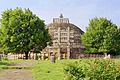
Large stupa from Sanchi (2nd / 1st century BC), Vidisha district

Kankali Devi Temple at Tigawa (around 420), Jabalpur District

Kandariya Mahadeva Temple (around 1050), Khajuraho , Chhatarpur District

Chhatris of Orchha (16th – 19th centuries), Tikamgarh district


.jpg)
Web links
- Official of the Government of Madhya Pradesh Website (English)
- Discover India: Madhya Pradesh
- Madhya Pradesh Tourism website
- Photos of landmarks in Madhya Pradesh
- Museums in Madhya Pradesh - photos and information
Individual evidence
- ^ Sub-national HDI - Area Database - Global Data Lab. Retrieved August 12, 2018 .
- ^ Indian States by Life Expectancy 2010-2014. (PDF) Retrieved March 19, 2018 .
- ^ Fertility Rates. (PDF) (No longer available online.) Archived from the original on June 18, 2018 ; accessed on March 19, 2018 . Info: The archive link was inserted automatically and has not yet been checked. Please check the original and archive link according to the instructions and then remove this notice.
- ^ Population of Indian States | Indian states population 1901-2011 - StatisticsTimes.com. Retrieved March 19, 2018 .
- ↑ Percentages according to the 2001 Indian census
- ↑ Census of India 2011: Population by religious community.
- ^ Museums in Madhya Pradesh
- ↑ a b Kamal Nath sworn in as Madhya Pradesh chief minister. The Times of India, December 17, 2018, accessed December 19, 2018 .
- ↑ Rahul Noronha: BJP's Shivraj Singh Chouhan sworn in as Madhya Pradesh CM for fourth time. indiatoday.in, March 22, 2020, accessed on March 26, 2020 .
- ^ Census of India 2011: Provisional Population Totals. Paper 1 of 2011: Madhya Pradesh. (PDF; 2.1 MB)
- ^ District Census Handbook Bhopal. (PDF) Census of India 2011, accessed on December 25, 2017 .
- ^ District Census Handbook Dindori. (PDF) Census of India 2011, accessed on December 25, 2017 .
- ↑ District Census Handbook Sheopur. (PDF) Census of India 2011, accessed on December 25, 2017 .
- ↑ Welcome to Barwani. Barwani District Administration, accessed December 25, 2017 .
- ^ District Census Handbook Katni. (PDF) Census of India 2011, accessed on December 25, 2017 .
- ^ Official Neemuch District Web site , accessed March 2, 2010
- ^ District Census Handbook Umaria. (PDF) Census of India 2011, accessed on December 25, 2017 .
- ^ District Census Handbook Harda. (PDF) Census of India 2011, accessed on December 25, 2017 .
- ^ District Census Handbook Burhanpur. (PDF) Census of India 2011, accessed on December 25, 2017 .
- ↑ District Census Handbook Anuppur. (PDF) Census of India 2011, accessed on December 25, 2017 .
- ^ District Census Handbook Ashoknagar. (PDF) Census of India 2011, accessed on December 25, 2017 .
- ^ District Census Handbook Alirajpur. (PDF) Census of India 2011, accessed on December 25, 2017 .
- ^ District Census Handbook Singrauli. (PDF) Census of India 2011, accessed on December 25, 2017 .
- ↑ Agar-Malwa to be 51st district of Madhya Pradesh. Department of Public Relation Madhy Pradesh, August 14, 2013, accessed September 22, 2015 .
- ^ MP State Biodiversity Board
| Today's states |
Andhra Pradesh • Arunachal Pradesh • Assam • Bihar • Chhattisgarh • Goa • Gujarat • Haryana • Himachal Pradesh • Jharkhand • Karnataka • Kerala • Madhya Pradesh • Maharashtra • Manipur • Meghalaya • Mizoram • Nagaland • Odisha • Punjab • Rajasthan • Sikkim • Tamil Nadu • Telangana • Tripura • Uttarakhand • Uttar Pradesh • West Bengal |
|
| Union Territories |
Andaman and Nicobar Islands • Chandigarh • Dadra and Nagar Haveli and Daman and Diu • Delhi • Jammu and Kashmir • Ladakh • Lakshadweep • Puducherry |
|
| Former states |
Ajmer • Andhra • Bhopal • Bilaspur • Bombay • Coorg • Hyderabad • Jammu and Kashmir • Kachchh • Madhya Bharat • Mysore • Patiala and East Punjab States Union • Saurashtra • Travancore-Cochin • Vindhya Pradesh |
Coordinates: 23 ° 15 ' N , 77 ° 30' E