
Arunachal Pradesh

|
|
| status | state |
| capital city | Itanagar |
| founding | February 20, 1987 |
| surface | 83,743 km² |
| resident | 1,383,727 (2011) |
| population density | 17 inhabitants per km² |
| languages | English |
| governor | BD Mishra |
| Chief Minister | Pema Khandu ( Congress Party ) |
| site | arunachalpradesh.gov.in |
| ISO code | IN AR |
 .svg) |
|
Arunachal Pradesh ( Hindi : अरुणाचल प्रदेश, Aruṇācal Pradeś [ ʌruˈɳɑːʧʌl prʌˈdeːɕ ]) is an Indian federal state with an area of 83,743 km² and a population of 1.4 million. The capital is Itanagar . It is disputed territory; the territory is claimed by China . The name Arunachal Pradesh comes from Sanskrit and means "land of the mountains in the dawn". The state is often referred to as the "Land of the Sunrise".
With a score of 0.661, Arunachal Pradesh ranks 15th among the 29 states of India in the 2015 Human Development Index .
geography

Arunachal Pradesh stretches for the most part over the southern slope of the eastern Himalayas , which is also commonly called the Assam Himalayas . It is part of the mighty mountain range, which is relatively low here overall, but is very rugged and is equipped with subtropical evergreen rainforest and cloud forest vegetation due to its humid monsoon climate . Only in the extreme west, in the district of Tawang , do the typical landscapes of Tibet appear, whose government in Lhasa had administered those areas of Arunachal Pradesh until the late 1940s.
Arunachal Pradesh borders the states of Assam and Nagaland to the south, Bhutan to the west , China ( Tibet ) to the north and Myanmar to the east .
According to the Chinese government , the disputed territory belongs to Cona , Mêdog and Zayü counties in Shannan and Nyingchi governorates of Tibet Autonomous Region .
population
demographics
As of the 2011 Indian Census, Arunachal Pradesh has a population of 1,383,727. In terms of population, Arunachal Pradesh is the third smallest state in India. The population density is the lowest of any state at 17 people per square kilometer and a fraction of the national average (382 people per square kilometer). At 22.7 percent, the urbanization rate is below the national average.
population development
The area of today's state was first counted in 1961. Previously, large areas in the mountainous part were excluded from censuses because they belonged to tribal areas. The growth was 311% in the fifty years between 1961 and 2011. The main reason for the huge increase in population is immigration from other regions of India. The population increase between 2001 and 2011 was 26.03% or around 286,000 people. Official population statistics have only been kept and published since 1961.
| year | 1961 | 1971 | 1981 | 1991 |
| resident | 336,558 | 467,511 | 631,839 | 864,558 |

Biggest cities
There are 27 places in the state that are considered cities (towns and census towns). Nevertheless, the proportion of the urban population is rather low. Because only 317,369 of the 1,383,727 inhabitants or 22.94% live in urban areas. The four places with more than 20,000 inhabitants are:
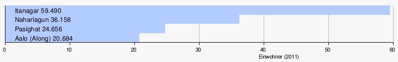
Other cities with a population of more than 10,000 people are (number of inhabitants in brackets): Seppa (18,350), Tezu (18,184). Namsai (14,246), Daporijo (13,405), Ziro (12,806), Roing (11,389) and Tawang (11,202).

ethnic groups
In India, the population is divided into three categories: general population , scheduled castes and scheduled tribes . The scheduled castes (“registered castes”) are now called Dalit (formerly also called pejoratively untouchables). The scheduled tribes are the recognized tribal communities with (2011) 951,821 people (68.78 percent of the population) who call themselves Adivasi ("native people"). They include 104 ethnic groups in Arunachal.
The population of Arunachal Pradesh is ethnically mixed. The majority of the inhabitants of the state belongs to a number of indigenous peoples, mostly as " tribal peoples " ( tribals are called) and get those particular by the Indian Constitution. The largest tribes are the Nissi , Adi Gallong , Wancho , Dafla , Monpa , Tagin , Adi Minyong , Nocte , Adi , Apatani , Galong , Mishmi , Nishang , Tangsa , Abor , Mishing (Miri), Khampti and Adi Padam . The remaining population consists of immigrants from other parts of India.
|
|
|
|
|
|
languages
| Languages in Arunachal Pradesh | ||||
|---|---|---|---|---|
| language | percent | |||
| Nissi (Dafla) | 28.62% | |||
| goodbye | 17.36% | |||
| Bengali | 7.27% | |||
| Hindi | 7.10% | |||
| Nepali | 6.89% | |||
| Wancho | 4.23% | |||
| Bhotia | 4.52% | |||
| Assamese | 3.90% | |||
| mishmi | 3.04% | |||
| Tangsa | 2.64% | |||
| night | 2.19% | |||
| Monpa (Takpa) | 0.90% | |||
| Miri (Mishing) | 0.75% | |||
| Other | 10.59% | |||
| Distribution of languages (2011 census) | ||||
Arunachal Pradesh has an enormous diversity of languages. The indigenous population speaks a variety of Tibeto-Burmese languages , most of whose names are identical to those of the corresponding tribes. As of the 2011 census, there are eight Tibeto-Burmese languages in Arunachal Pradesh whose speakers make up at least one percent of the total population, with none of them accounting for significantly more than one fifth. These are (in order of magnitude) Nissi , Adi , Wancho , Bhotia , Mishmi , Tangsa , Miri and Nocte . In addition, there are numerous other small languages with a limited area of distribution and a small number of speakers, which are often only insufficiently documented. It was not until 2008 that the discovery of a previously unknown Tibeto-Burman language called Koro with 800 to 1200 speakers was reported.
Among the non-indigenous population, the Indo-Aryan languages Bengali , Hindi and Nepali (each around 7 percent) and Assamese (just under 4 percent) are widespread. English is the sole official language .
religions
| Religions in Arunachal Pradesh | ||||
|---|---|---|---|---|
| religion | percent | |||
| Christianity | 30.3% | |||
| Hinduism | 29.0% | |||
| Buddhism | 11.8% | |||
| Islam | 2.0% | |||
| Other | 26.9% | |||
| Distribution of religions (2011 census) | ||||

In terms of religion, too, Arunachal Pradesh is mixed and differs greatly from the Indian average. According to the 2011 census, 30 percent of the population is Christian , 29 percent is Hindu , 12 percent is Buddhist, and 2 percent is Muslim . 26 percent of the residents are listed in the census statistics under "other religions". These are primarily animistic beliefs of the indigenous population ( Adivasi ).
A large part of the indigenous population practices ethnic religions or has converted to Christianity. The Monpa and other tribes in western Arunachal Pradesh are culturally close to neighboring Tibetans and are Lamaist Buddhists. In the east of the state, however, Theravada Buddhism is widespread among the Khampti, as in neighboring Burma . Above all, the non-indigenous population in the cities adheres to Hinduism, while the Nocte and Wancho tribes also practice an elementary form of Vishnuism .
story
The majority of the peoples inhabiting Arunachal Pradesh were illiterate until the 20th century and therefore have no historical records. Only the Monba population in the Tibetan-influenced Tawang in the northwest of Arunachal has written records as a small principality.
At the latest in the 17th century, in the time of the 5th Dalai Lama Ngawang Lobsang Gyatsho , the region came under the sphere of influence of the Tibetan Gelug school and was ruled by Lhasa . After the invasion of the British Younghusband expedition to Tibet , a military campaign to Lhasa, which led to the flight of the 13th Dalai Lama Thubten Gyatsho , the British had Tawang and the adjoining areas ceded to the Tibetans. This was laid down in the treaty of the Shimla Conference (1914), which was not ratified by the Chinese side , which wanted to establish the main Himalayan ridge ( McMahon Line ) on the border between Tibet and British India .

As a result, the British formed the so-called North-East Frontier Tracts (NEFT) from these areas , only loosely administered areas with relatively autonomous tribal populations. After India's independence in 1947, the Indian government also took over the former claims of the British and tried to integrate the region into the young state. In 1951 the NEFT was reorganized as the North-East Frontier Agency (NEFA). In October and November 1962, the Indo-Chinese Border War broke out . In the course of this, Chinese troops advanced as far as the Assam Plains on the northern bank of the Brahmaputra , but withdrew a few weeks later to their starting positions north of the McMahon Line.
On January 20, 1972, the former NEFA was granted Union Territory status, renamed Arunachal Pradesh. It became a state on February 20, 1987, with the establishment of a Legislative Assembly, which was first elected in February 1978.
The People's Republic of China maintains a claim to the area. This special situation of Arunachal Pradesh expresses u. also that Indian special permits are required to enter this state – not only for foreigners, but also for non-resident Indians.
politics
Political system
Arunachal Pradesh has had its own government with an elected Chief Minister since 1975 and its own legislature consisting of a unicameral parliament , the Arunachal Pradesh Legislative Assembly . The 60 members of Parliament are elected every five years by direct election . 59 seats are reserved for members of the indigenous tribal peoples ( Scheduled Tribes ). The Parliament is based in Itanagar . The Chief Minister (Head of Government) of Arunachal is elected by Parliament. But is appointed by the President of India Governor (at the head of the State Governor ). Its main tasks are the appointment of the Chief Minister and his task of forming a government. The highest court with jurisdiction over Manipur is the Gauhati High Court , based in Guwahati , which has jurisdiction over all of north-east India. A branch is located in Itanagar.
Arunachal Pradesh has two MPs in the Lok Sabha , the lower house of the Indian Parliament, and one in the Rajya Sabha , the Indian upper house.
parties
| Political party | seats |
|---|---|
| Indian National Congress (INC) | 42 |
| Bharatiya Janata Party (BJP) | 11 |
| People's Party of Arunachal (PPA) | 5 |
| independent | 2 |
| total | 60 |
The dominant political force in Arunachal Pradesh has been the Indian National Congress . The Congress party has led all governments since the state was founded in 1975 until 2016. In the last parliamentary elections in May 2014, the Congress party again won an absolute majority with 42 out of 60 seats. The Hindu nationalist Bharatiya Janata Party (BJP) won eleven constituencies. Five constituencies went to the regional People's Party of Arunachal (PPA) and two to independent candidates. As a result of the election, Chief Minister Nabam Tuki, who had been in office since November 2011, was confirmed in office by the Congress party. In the simultaneous all- India parliamentary elections in 2014 , the Congress Party won one of the two constituencies in Arunachal Pradesh, while the BJP won the other.
A government crisis erupted in January 2016 when 16 MPs in the regional parliament split from the Congress Party and called for Tuki to be voted out of office. On January 26, 2016, the government was suspended and the state was placed under the control of the central government ( president's rule ) until February 19, 2016 . The dissidents were expelled from the Congress Party and merged with the People's Party of Arunachal on March 3, 2016. On 19 February 2016, the leader of the dissident faction , Kalikho Pul , was elected the new Chief Minister after garnering the support of BJP MPs and some independents. However , the Supreme Court ruled the imposition of president's rule illegal on July 13, 2016. From July 16, 2016, Pema Khandu (Congress Party) served as the new Chief Minister. Congress party dissidents largely returned to the Congress party.
administrative division
The state of Arunachal Pradesh is divided into the following 21 districts (as of 2014) (number of inhabitants and population density according to provisional results of the 2011 census):
- C = code, J = year of foundation, GV = gender distribution
| C | district | administrative seat |
site plan | J | Area in km² |
population (2011) |
Eh. / km² | GM | Population growth in % (2001–2011) |
Literacy sierungs- rate in% |
|---|---|---|---|---|---|---|---|---|---|---|
| AJ | Anyaw | hawaiian |
.svg) |
2004 | 6190 | 21,089 | 3.4 | 1,242 | 13.77 | 59.40 |
| CH | Changlang | Changlang |
.svg) |
1987 | 4662 | 147,951 | 31.7 | 1,094 | 11.96 | 61.90 |
| Dibang Valley | Anini |
.svg) |
2001 | 9129 | 7,948 | 0.9 | 1,238 | 9.30 | 64.80 | |
| EK | East Kameng | seppa |
.svg) |
1980 | 4134 | 78,413 | 19.0 | 0.988 | 37:14 | 62.48 |
| IT | East Siang | Pasighat |
.svg) |
1980 | 4005 | 99,019 | 24.7 | 1,039 | 13.30 | 73.54 |
| Kra Daadi | jamin | 2015 | ||||||||
| Kurung Kumey | coloring |
.svg) |
2001 | 5981 | 89,717 | 15.0 | 0.972 | 111.01 | 50.67 | |
| LD | longding | longding | 2012 | |||||||
| el | Lohit | Tezu |
.svg) |
1980 | 5212 | 145,538 | 27.9 | 1,110 | 16.44 | 69.88 |
| U.D | Lower Dibang Valley | Roing |
.svg) |
2001 | 3856 | 53,986 | 14.0 | 1.166 | 36.76 | 70.38 |
| Lower Siang | Likabali | 2017 | ||||||||
| LB | Lower Subansiri | Ziro |
.svg) |
1980 | 3452 | 82,839 | 24.0 | 1,026 | 48.65 | 76.33 |
| namsai | namsai | 2014 | ||||||||
| PA | Papum Pare | Yupia |
.svg) |
1992 | 2875 | 176,385 | 61.3 | 1,053 | 44.57 | 82.14 |
| Siang | Pangin | 2015 | ||||||||
| TA | Tawang | Tawang |
.svg) |
1984 | 2172 | 49,950 | 23.0 | 1,427 | 28.33 | 60.61 |
| ti | Tirap | Khonsa |
.svg) |
1965 | 2362 | 111,997 | 47.4 | 1,074 | 11.63 | 52.23 |
| U.S | Upper Siang | Yingkiong |
.svg) |
1994 | 6188 | 35,289 | 5.7 | 1.122 | 5.77 | 59.94 |
| UB | Upper Subansiri | Daporijo |
.svg) |
1980 | 7032 | 83.205 | 11.8 | 1.018 | 50.34 | 63.96 |
| WK | West Kameng | Bomdila |
.svg) |
1980 | 7422 | 87.013 | 11.7 | 1,325 | 16.64 | 69.40 |
| WS | West Siang | eel |
.svg) |
1980 | 8325 | 112,272 | 13.5 | 1,092 | 8.04 | 67.62 |
Since the beginning of 2011, further districts have been formed in Arunachal Pradesh or are being planned:
- LongDing based in Long Ding was split on 26 September 2011 by the district Tirap.
- Namsai based in Namsai was split on 15 August 2014 by the district Changlang.
- Based in Palin , Kra Daadi was split off from Kurung Kumey District on February 8, 2015.
- Based in Likabali , Lower Siang was formed in 2017.
- Middle Siang and Arunachal Pradesh Capital District are other planned districts.
personalities
- The 6th Dalai Lama Tsangyang Gyatso was born in 1683 in the town of Tawang.
web links
itemizations
- ↑ Sub-national HDI - Area Database - Global Data Lab. Retrieved August 12, 2018 (English).
- ↑ Census of India 2011: Distribution of population, sex ratio, density and decadal growth rate of population : 2011. ( Memento of 9 April 2011 in the Internet Archive )
- ↑ Census of India 2011: Provisional Population Totals - India - Rural-Urban Distribution. (PDF; 8.1MB)
- ↑ Census of India, Decadal Variation in Population since 1901 in Arunachal Pradesh
- ↑ Population figures of the cities at citypopulation
- ↑ A-11 Individual Scheduled Tribe Primary Census Abstract Data and its Appendix' (excel)
- ↑ Census of India 2011: Statement - 3 Distribution of 10,000 Persons by Language - India, States and Union Territories - 2011 and Distribution of the 99 Non-Scheduled Languages-India/States/Union Territories .
- ↑ Morrison, Dan "'Hidden' Language Found in Remote Indian Tribe" . National Geographic Daily News , October 5, 2010
- ↑ Census of India 2011: Population by religious community.
- ↑ Arunachal Pradesh. (No longer available online.) knowindia.gov.in Archived from the original on November 22, 2016 ; Retrieved 11 October 2016 (English).
- ↑ Election Commission of India.
- ↑ Arunachal Chief Minister Kalikho Pul, 29 Congress MLAs join PPA. dnaindia.com, March 3, 2015, accessed May 25, 2016 (English).
- ↑ Bikash Singh: Arunachal Pradesh crisis: 31 MLAs in tow, Kalikho Pul makes bid for chief ministerial berth. The Economic Times, February 16, 2016, accessed May 25, 2016 .
- ↑ President's rule lifted in Arunachal Pradesh. The Hindu, February 19, 2016. Retrieved May 25, 2016 .
- ↑ As it happened: Tuki resigns, Khandu stakes claim, Governor yet to respond. The Hindu, 2016-07-17, accessed 2016-08-10 .
- ↑ State Profile of Arunachal Pradesh. Ministry of Micro, Small and Medium Enterprises, Government of India, 2014, pp. 12-15 , accessed 21 November 2017 .
- ↑ Census of India 2011: Provisional Population Totals. Paper 1 of 2011: Arunachal Pradesh. (PDF; 21.7MB)
- ↑ a b c d Longding is included as part of Tirap .
| Present States |
Andhra Pradesh • Arunachal Pradesh • Assam • Bihar • Chhattisgarh • Goa • Gujarat • Haryana • Himachal Pradesh • Jharkhand • Karnataka • Kerala • Madhya Pradesh • Maharashtra • Manipur • Meghalaya • Mizoram • Nagaland • Odisha • Punjab • Rajasthan • Sikkim • Tamil Nadu • Telangana • Tripura • Uttarakhand • Uttar Pradesh • West Bengal |
|
| Union Territories |
Andaman and Nicobar Islands • Chandigarh • Dadra and Nagar Haveli and Daman and Diu • Delhi • Jammu and Kashmir • Ladakh • Lakshadweep • Puducherry |
|
| Former States |
Ajmer • Andhra • Bhopal • Bilaspur • Bombay • Coorg • Hyderabad • Jammu and Kashmir • Kachchh • Madhya Bharat • Mysore • Patiala and East Punjab States Union • Saurashtra • Travancore-Cochin • Vindhya Pradesh |
Coordinates: 28° 0′ N , 95° 0′ E