
Nagaland
 |
|
| status | State |
| Capital | Kohima |
| founding | December 1, 1963 |
| surface | 16,527 km² |
| Residents | 1,980,602 (2011) |
| Population density | 119 inhabitants per km² |
| languages | English |
| governor | RN Ravi |
| Chief Minister | Neiphiu Rio ( NDPP ) |
| Website | nagaland.nic.in |
| ISO code | IN-NL |
 .svg) |
|
Nagaland is an Indian state with an area of 16,527 square kilometers and almost two million inhabitants (as of 2011). The capital of Nagaland is Kohima , the official language is English . Nagaland is named after the Naga ethnic group .
geography

Position and extent
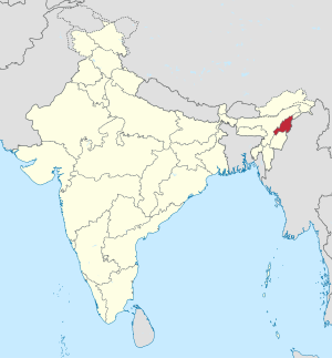
Nagaland is located in the far northeast of India between 93 ° 20 'and 95 ° 15' east longitude and north of the equator between 25 ° 6 'and 27 ° 4' north latitude. With an area of 16.527 km², the federal state roughly corresponds in size to the German state of Thuringia or the Austrian state of Styria . Nagaland is bounded in the east by the international border with Myanmar. It is bordered by the state of Arunachal Pradesh to the north, Assam to the west and Manipur to the south . The country's nature is characterized by mountain and hill country. The highest peaks are to be found in the northeast. The highest mountain is the Saramati (3826–3841 m) and the second highest is the Japfü (3020–3043 m). Nagaland is one of the so-called " Seven Sister States " that make up northeast India.
climate
The climate varies according to the changeable topography. In the regions between 1000 and 1200 meters above sea level , the climate is subtropical, warm to hot. The average annual temperature in the valleys is 23 ° C to 25 ° C, in the slightly higher regions it is 18 ° C to 20 ° C. The highest mountain Saramati is snow-covered in winter. The climate is strongly influenced by the monsoon , which lasts 5 months from May to September. June to August are the rainiest months and the coldest month is January.
Flora and fauna


According to the very different climate zones, Nagaland has a very diversified fauna and flora . According to official information, around 55% of the country's area was covered with forest in 2013 . Compared to previous surveys, the forest population had decreased significantly. The forests range from evergreen tropical rainforest to subtropical rainforest to coniferous forests and alpine trees in the higher mountain regions.
At least 106 species of mammals can be found in Nagaland, including nine insectivores, 34 species of bat, seven species of primate, one pangolin , 34 carnivores, the Asian elephant , seven types of ungulates, and at least 12 species of rodents . The seven primate species Sunda Slow Loris ( Nycticebus coucang ), northern pig-tailed macaque ( Macaca leonina ), rhesus monkey ( Macaca mulatto ), Assam Macaque ( Macaca assamensis ), stump-tailed macaque ( Macaca arctoides ), capped langur ( Trachypithecus pileatus ) and the Hulock ( Hylobates hoolock ). Of the five smaller felines that occur , three - the marble cat ( Pardofelis marmorata ), the Asian golden cat ( Catopuma temmincki ) and the fish cat ( Prionailurus viverrinus ) - have become extremely rare. The Bengal tiger , which used to be more common in the past, has become extremely rare, as is the Indian leopard ( Panthera pardus fusca ) and the clouded leopard ( Neofelis nebulosa ). The Sumatran rhinoceros that used to be found is extinct and there are only a few elephants left. The Gaur has also become very rare. Nagaland has a very rich bird life with an estimated 400 species. The gharial has almost been exterminated from the reptiles and some species of turtles and lizards have also been severely decimated.
Biggest cities
(Status: 2001 census)
| city | Residents |
|---|---|
| Dimapur | 107,382 |
| Kohima | 78,584 |
| Wokha | 37,696 |
| Moching | 31.204 |
| Tuensang | 29,654 |
| Zunheboto | 22,809 |
population
Demographics
| Languages in Nagaland | ||||
|---|---|---|---|---|
| language | percent | |||
| Ao | 14.2% | |||
| Konyak | 13.7% | |||
| Lotha | 9.3% | |||
| Angami | 7.3% | |||
| Phom | 6.8% | |||
| Sema | 5.1% | |||
| Yimchungru | 5.1% | |||
| Sangtam | 4.7% | |||
| Chakru | 4.6% | |||
| Chang | 3.4% | |||
| Zeliang | 3.4% | |||
| Bengali | 3.3% | |||
| Rengma | 3.2% | |||
| Hindi | 3.2% | |||
| Khezha | 2.2% | |||
| Khiamniungan | 2.1% | |||
| Nepali | 1.9% | |||
| Other | 6.4% | |||
| Distribution of languages (2001 census) | ||||

According to the 2011 Indian census , Nagaland has 1,980,602 inhabitants. This makes Nagaland one of the smaller states of India. The population density of Nagaland is 119 inhabitants per square kilometer and is thus well below the overall Indian average of 382 inhabitants per square kilometer. 29.0 percent of the state's residents live in cities. The degree of urbanization thus corresponds to the national average of 31.2 percent. Nagaland is the only state in India to have a negative population trend: Between 2001 and 2011, the population shrank by 0.5 percent. The literacy rate in Nagaland in the 2001 census was 80.1 percent, above the Indian average (74.0 percent).
Nagaland is predominantly settled by Naga . It is a generic term for a group of indigenous peoples from the Indian northeast. Indian government agencies count them among the "tribal peoples" who have special rights ( scheduled tribes ). According to the 2001 census, the Naga make up 87.5 percent of the state's population and are divided into 16 different tribes. These are (in order of magnitude) the Konyak , Sema , Ao , Lotha , Chakhesang , Angami , Phom , Sangtam , Yimchungrü , Zeliang , Chang , Rengma , Khiamniungan , Pochury , Tikhir and Chirr . In addition to the Naga, another 1.6 percent of Nagaland's inhabitants are counted among the tribal population. Most of them are members of the Kuki . The remaining population is made up of immigrants from other parts of India.
languages
There is an enormous variety of languages in Nagaland. The different Naga tribes speak different Tibetan Burman languages from the subgroup of the Kuki-Chin-Naga languages , whose names are mostly identical to those of the corresponding tribes. Mutual communication between the speakers of the different Naga languages is not possible. According to the 2001 census, there are 14 Naga languages in Nagaland, each of whose speakers make up at least one percent of the total population, with none of them reaching a share of more than 15 percent. These languages are Ao , Konyak , Lotha , Angami , Phom , Sema , Yimchungrü , Sangtam , Chakru , Chang , Zeliang , Rengma , Khezha and Khiamniungan (in descending order of the number of speakers) .
The Indo-Aryan languages Bengali (3.3 percent), Hindi (3.2 percent), Nepali (1.9 percent) and Assamese (0.9 percent) are spoken among the non-indigenous population . One serves as a lingua franca Nagamesisch called Pidgin based on the Assamese. The official language of the state is English .
Religions
| Religions in Nagaland | ||||
|---|---|---|---|---|
| religion | percent | |||
| Christianity | 87.9% | |||
| Hinduism | 8.7% | |||
| Islam | 2.5% | |||
| Other | 0.9% | |||
| Distribution of religions (2011 census) | ||||
The predominant religion in Nagaland is Christianity . According to the 2011 census, 88 percent of the state's population are Christian. Nagaland is thus the Indian state with the highest Christian population and, in addition to the states of Mizoram and Meghalaya, which are also located in the Indian north-east, one of three states in which Christians make up the majority of the population. The high Christian population is a result of the Christianization of the Naga by American missionaries from the late 19th century. The majority of Christians in the state are Baptists . Nagaland is considered to be the region with the world's highest Baptist population. Hinduism (8.7 percent) and Islam (2.5 percent) are common among the population who immigrated from other parts of India .
history

The exact origin of the eponymous Naga tribes is unknown. Immigration from southwest China, southeast Asia or the northern Mongolian regions is being discussed. When the Ahom Empire was established in Assam in 1228, the Naga were already settled in what was later to become Nagaland. The Nagas lived in warlike tribal societies and practiced headhunting , among other things . After the end of the Ahom Empire in Assam, it came under the control of the British East India Company in 1826 . The Nagas came into conflict with the British through their practice of raiding the lowlands, and the British responded with various punitive expeditions to Nagaland, which, however, did not lead to lasting pacification. In 1866 the British-Indian administration set up an administrative post in Samaguting (from 1878 in Kohima ) to organize the area administratively. In 1879/80 a nationwide uprising broke out, which was suppressed by British troops in the battle of Khonoma. After that, the Naga largely gave up their armed resistance. In the following years Christian missionaries came to the country who converted a large part of the population from the previous ethnic religions to Christianity . Part of the country was organized as a district by the British ( Naga Hills district ), the part further to the mountainous region remained largely unorganized ( Naga tribal area ). Formally, the areas were subordinate to the governor of the province of Assam.
During the Second World War, neighboring Burma was occupied by Japanese troops . Combat operations took place in Nagaland, including the Battle of Kohima from April 4 to June 22, 1944, which marked the beginning of the British counter-offensive in Burma.

Even in the times of British India, the Naga retained a pronounced self-confidence. This was reflected in the January 10, 1929 memorandum submitted by Naga leaders to the British Simon Commission . In it, the Nagas asked the colonial administration to further respect their special rights. After the end of British colonial rule in 1947, Nagaland joined India. In the first years after independence, Naga politicians demanded the amalgamation of all Naga areas (the division into Naga Hills district and Naga tribal area continued) as well as extensive autonomy of Nagaland and toying with complete independence. There were armed clashes, which led to the long deployment of the Indian army.
On December 1, 1957, the Naga Hills-Tuensang Area Act, 1957, came into force, which formed the Naga Hills-Tuensang Area (NHTA) from Naga Hills district and Naga tribal area, which was administered centrally by the Governor of Assam Territory received. This status did not satisfy the Naga and the violent clashes between the state authorities and militant Naga activists continued. The clashes largely came to an end when Nagaland became a separate Indian state on December 1, 1963, with the State Of Nagaland Act coming into force in 1962 .
politics
Political system
The legislature of the state of Nagaland consists of a unicameral parliament , the Nagaland Legislative Assembly . The 60 members of parliament are elected by direct election every five years . The parliament has its seat in Kohima . The Chief Minister (Head of Government) Nagaland, is elected by Parliament. But is appointed by the President of India Governor (at the head of the State Governor ). Its main tasks are to appoint the Chief Minister and to entrust him with the formation of the government. The highest court responsible for Nagaland is the Gauhati High Court , based in Guwahati . There is a branch in Kohima.
Nagaland has one member each in the Lok Sabha , the lower house of the Indian parliament, and in the upper house, the Rajya Sabha .
Parties
| Distribution of seats after the 2018 parliamentary elections |
|
|---|---|
| NPF | 27 |
| NDPP | 17 † |
| BJP | 12 |
| NPP | 2 |
| JD (U) | 1 |
| Independent | 1 |
| total | 60 |
|
† There was no election in the constituency of Northern Angami-II , as there was only one candidate, Neiphiu Rio (NDPP), who was declared automatically elected. |
|
Nagaland has been ruled by the Naga People's Front (NPF) regional party since 2003 . In the parliamentary elections in February 2013, she won an absolute majority with 38 out of 60 seats. The main opposition party was the Congress Party , which had six MPs. The Nationalist Congress Party (NCP) with four seats, the Bharatiya Janata Party (BJP) and the Janata Dal (United) (JD (U)) with one seat each and seven independent candidates were also represented in parliament . As a result of the election, the NPF politician Neiphiu Rio was confirmed in office. After Rio moved into the Lok Sabha , his party colleague TR Zeliang replaced him on May 24, 2014 as Nagaland's chief minister. The NPF also won the Nagaland constituency in the all-India parliamentary elections in 2004 , 2009 and 2014 .
On November 22, 2015, all 8 MPs of the Congress Party in the parliament of the ruling party NPF joined, so that afterwards all MPs belonged to the ruling coalition.
In January 2017, public protests sparked over the question of a 33% quota for women in local parliament elections. Various tribal organizations have argued that the quota enshrined in India's constitution violates constitutional clause 371A, which gives Nagas special protection for political and social customs. On January 31, 2017, two youths were killed in clashes in Dimapur. Further unrest and general strikes ( bandhs ) forced Chief Minister TR Zeliang to resign on February 19, 2017. He was succeeded by Shurhozelie Liezietsu on February 22, 2017 . TR Zeliang then gathered his supporters in the NPF faction and led an intra-party revolt against his successor. Despite being expelled from the NPF, he managed to gain enough support from MPs so that he was reappointed Chief Minister on July 19, 2017. Liezietsu and Zeliang came to an agreement in the following years and united their political forces to prevent a political comeback of the former party chairman Neiphiu Rio in Nagaland.
In the parliamentary elections in Nagaland on February 27, 2018, there were significant shifts in the spectrum of parties. The Bharatiya Janata Party (BJP), which won only one of the 60 constituencies in the 2013 election, won 12. This time the NPF won 27, the Nationalist Democratic Progressive Party (NDPP), a split from the NPF allied with the BJP, came to 16 mandates. The National People's Party (NPP) won two seats, and an independent and a candidate from Janata Dal (United) received one seat each .
On March 8, 2018, the NDPP party leader Neiphiu Rio was appointed as the new Chief Minister by the governor. His government is largely supported by the BJP.
Administrative division
The state of Nagaland is divided into the following eleven districts (population and population density according to the 2011 census):

| District | Administrative headquarters | surface | Population (2011) |
Population density |
|---|---|---|---|---|
| Dimapur | Dimapur | 926 km² | 379.769 | 410 inhabitants / km² |
| Kiphire | Kiphire | 1,122 km² | 74,033 | 66 people / km² |
| Kohima | Kohima | 1,268 km² | 270.063 | 213 inhabitants / km² |
| Longleng | Longleng | 568 km² | 50,593 | 89 people / km² |
| Moching | Moching | 1,610 km² | 193.171 | 120 people / km² |
| Mon | Mon | 1,791 km² | 250,671 | 140 inhabitants / km² |
| Peren | Peren | 1,726 km² | 94,954 | 55 people / km² |
| Phek | Phek | 2,016 km² | 163.294 | 81 people / km² |
| Tuensang | Tuensang | 2,187 km² | 196,801 | 90 people / km² |
| Wokha | Wokha | 1,630 km² | 166.239 | 102 people / km² |
| Zunheboto | Zunheboto | 1,259 km² | 141.014 | 112 inhabitants / km² |
economy
With a score of 0.681, Nagaland ranks 11th among the 29 states of India in the Human Development Index in 2015 .
Agriculture
.jpg)
Nagaland's economy is still relatively strongly influenced by agriculture. In 2011 45.5% of the population were employed in this sector. However, the contribution of agriculture to the overall economic value added is continuously decreasing and amounted to around 28.1% in 2016/17. The main activities are terrace rice cultivation , wet rice cultivation and traditional slash and burn . Rice is the most important cultivated staple food and is grown on just over 50% of the agricultural area. The total rice production in 2016/17 was 478,210 tons. The cultivation of fruit and vegetables is increasing significantly and is supported by the government. Between 2011/12 and 2014/15, production increased by 85 and 117%, respectively. Are grown pineapple , banana , citrus , lemongrass , passion fruit , black cardamom , turmeric , papaya and lychee . Coconut , betel nut , cashew nut and coffee beans are harvested from plantation crops . Even the ornamental horticulture plays with the production of roses , lilies , alstroemeria , anthurium , gerberas and orchids a role.
The official statistics counted 3.2 million farm animals in 2012 , including around half a million pigs, 2 million domestic chickens, and 235,000 cattle. In 2015/16, the consumption of meat, eggs and milk was around 50 percent higher than the company's own production, so that these are essential import goods. The government is therefore promoting livestock husbandry, especially pig breeding.

The total forest area was put at 13,347 km² in 2013, which corresponds to about 80.5% of the area of the state. Before that, however, only 134 km² were classified as “very dense forest”, 28.3% as “moderately dense” and 42.1% as “open forest”. The Kohima district had the highest proportion of forest area (87%) and the Dimapur district the lowest (54%). Rapidly advancing deforestation is seen as a problem.
Trade, commerce and industry as well as mineral raw materials
Although the Nagaland governments have been trying for years to attract export-oriented trades and industries in particular, their successes have so far been rather modest. The industry is poorly developed. Textile processing companies and those that process agricultural products dominate.
Nagaland is considered to be rich in mineral raw materials. These include oil and gas reserves in the northwest along the border with Assam, the reserves of which are estimated at 600 million tons. Coal deposits are estimated at 317 million tons and limestone and marble resources at 1,000 million tons. In addition, there are around 5 million tons of various non-ferrous metals ( nickel , cobalt and chromium ), other metals such as zinc and molybdenum , and possibly also precious metal deposits ( gold , platinum ) in the southwestern districts of Phek , Kiphire and Tuensang .
tourism

Tourism is given great potential for growth. So far it is only slightly developed. In the 2016–2017 season, 58,178 local and 3,260 foreign tourists visited Nagaland. The annual Hornbill Festival in December is a major tourist attraction . Prohibition has been in effect in Nagaland since 1989 , i. H. the purchase of alcoholic beverages is not legally possible. Private consumption is not a criminal offense and the controls are reportedly very superficial.
Infrastructure
Roads and railways

In Betzug, road transport has the greatest importance on the transport infrastructure. In 2016/16 there were 12,080 kilometers of roads. There were also 1,546.7 km of national highways . In August 2016, the then Railway Minister Suresh Prabhu laid the foundation stone for the 88 km long Dimapur - Zubza - Kohima railway line . The start of construction was delayed by 6 years due to property issues.
Air traffic

Air traffic is of little importance within Nagaland (there are a few helicopter connections). The only major airport is Dimapur Airport , which is 7 km from Dimapur and about 70 km from Kohima . From here there are scheduled flights to Calcutta in West Bengal and Dibrugarh in Assam.
Power supply
In 2015/16, 59 percent of electrical energy was obtained from hydropower, 17% from coal and 24 percent from gas. In the dry season (November to May) the proportion of hydropower is reduced to around 30 percent, which repeatedly resulted in bottlenecks. On the other hand, in the rainy monsoon period, the maximum capacities cannot be used at all due to insufficient power grids . The peak demand was 156 MW in 2015/16 and it has been estimated that this will increase to 250 MW and 500 MW by 2020 and 2030, respectively. In 2015/16 of the 436,217 households, 141,049 (32%) were not yet electrified, 24,566 of them in urban and 116,483 in rural regions.
Postal services
The postal system was continuously expanded. In 2014/15 there were 328 post offices.
Nature parks and nature conservation
Nagaland had a national park and three wildlife sanctuaries in 2016 . The idea of environmental protection is gradually penetrating the general consciousness through large-scale education programs and the involvement of the local population. An example of this is the extensive decline in hunting for the Amur falcon , up to around 100,000 of which were previously caught and killed in large nets each year. After international protests, hunting was banned and a large-scale education program began, so that the migratory birds have been flying largely unhindered through Nagaland since 2013.
| No. | Surname | Area ( ha ) | Legal basis / year of establishment |
|---|---|---|---|
| 1 | Intangki National Park | 20,200 | 1975 (as Intangki Wildlife Sanctuary ) |
| 2 | Singphan Wildlife Sanctuary | 2,357 | The Wildlife (Protection) Act, 1972 |
| 3 | Puliebadze Wildlife Sanctuary | 923 | Nagaland Jhum Act, 1974 |
| 4th | Fakim Wildlife Sanctuary | 640 | Wildlife (protection) Act, 1972 |
Web links
- Website of the Government of Nagaland (English)
- Detailed German travel report with (little precise) background information
Individual evidence
- ↑ a b National Disaster Risk Reduction Portal. (PDF) National Institute of Disaster Management, archived from the original on June 26, 2014 ; accessed on May 9, 2017 (English).
- ↑ ENVIS Center: Nagaland: Status of Environment and Related Issues. Indian Ministry of the Environment, archived from the original on May 27, 2017 ; accessed on May 9, 2017 (English).
- ↑ ENVIS Center: Nagaland: Status of Environment and Related Issues Forest Resource: Forests. Indian Ministry of the Environment, archived from the original on April 27, 2017 ; accessed on May 9, 2017 (English).
- ↑ ENVIS Center: Nagaland: Status of Environment and Related Issues: fauna. Indian Ministry of the Environment, archived from the original on May 27, 2017 ; accessed on May 9, 2017 (English).
- ^ Census of India 2001: Statement - 3 Distribution of 10,000 Persons by Language - India, States and Union Territories - 2001 and Distribution of the 100 Non-Scheduled Languages-India / States / Union Territories .
- ^ Census of India 2001: Provisional Population Tables and Annexures ( Memento of January 10, 2012 in the Internet Archive ) and Provisional Population Totals - India - Rural-Urban Distribution. (PDF; 8.1 MB)
- ^ Census of India 2001: Nagaland. Data highlights: The Scheduled Tribes. (PDF; 68 kB)
- ↑ Census of India 2011: Population by religious community.
- ↑ Charles Chasie: Nagaland in Transition . Where the Sun Rises When Shadows Fall: The North-east. In: India International Center Quarterly . tape 32 , no. 2/3 , 2005, p. 253-264 , JSTOR : 23006032 (English).
- ↑ a b Nagaland State Human Development Report. (PDF) Department of Planning & Coordination, Government of Nagaland, September 15, 2004, pp. 19–22 , accessed on February 12, 2017 (English).
- ^ Suresh K. Sharma (ed.): Documents on North-East India: Nagaland , Chapter 9: Naga Memorandum to Simon Commission . Pp. 33ff , Mittal Publications; 1st edition (2006)
- ↑ The Naga Tuensang Area Hills- Act, 1957. indiankanoon.org, November 29, 1957. Retrieved on 12 February 2017 (English).
- ^ The State Of Nagaland Act, 1962. indiankanoon.org, September 4, 1962, accessed February 12, 2017 .
- ↑ a b Nagaland Result. Indian Election Commission, accessed March 4, 2018 .
- ↑ Nagaland Assembly elections 2018: Neiphiu Rio elected unopposed before polls. The Indian Express, February 13, 2018, accessed March 4, 2018 .
- ↑ In blow to Cong, 8 MLAs join Naga People's Front. The Times of India, November 22, 2015, accessed August 24, 2016 .
- ↑ Uddipta Das: Nagaland violence: Government building torched, Paramilitary forces deployed at Kohima (india.com, February 2, 2017, English, accessed February 24, 2017)
- ↑ Maduli Thaosen: Turmoil In Nagaland Over 33% Reservation For Women In Local Bodies (feminisminindia.com, February 9, 2017, English, accessed February 24, 2017)
- ↑ Nagaland chief minister TR Zeliang resigns amidst political turmoil ( The Times of India , February 19, 2017, English, accessed February 24, 2017)
- ↑ Shurhozelie Liezietsu sworn in as Nagaland Chief Minister ( The Hindu , February 22, 2017, English, accessed February 24, 2017)
- ↑ Kangkan Acharyya: TR Zeliang Proves majority in House: Party-less Nagaland CM Achieves new feat in Indian politics. July 20, 2017, accessed September 3, 2017 .
- ^ Census of India 2011: Provisional Population Totals. Nagaland. Population and decadal growth rate by residence (PDF; 2.4 MB) and Density of population. (PDF; 360 kB)
- ^ Sub-national HDI - Area Database - Global Data Lab. Retrieved August 12, 2018 .
- ↑ a b c d Economic Survey 2016-17: Agriculture and Allied Sector: (1. Agriculture, 2. Horticulture, 3. Livestock, 5. Forest, Ecology, Environment and Wildlife). Department of Economics & Statistics, Kohima, Nagaland, accessed May 28, 2017 .
- ^ A b Economic Survey 2016-17: Mineral Resources (1. Industries and Commerce, 2. Mineral Resources). Department of Economics & Statistics, Kohima, Nagaland, accessed May 31, 2017 .
- ↑ a b c d Economic Survey 2016-17: Infrastructure Sector: (1. Power and Electricity, 2. Road, Transport and Communication, 4. Tourism). Department of Economics & Statistics, Kohima, Nagaland, accessed May 31, 2017 .
- ↑ Prakash Chandra Verma: People's Dialogue on Education . In: People's Dialogue on Education . tape 8 , no. 1 . Politicindia, January 2016, ISSN 0974-5955 (English).
- ^ North Eastern Region. (PDF) Indian Railways , November 2010, accessed on May 31, 2017 (English).
- ↑ DMU / VEMR: Dimapur Airport, India. Retrieved May 31, 2017 .
- ↑ Economic Survey 2016-17: Agriculture and Allied Sector: 5. Forest, Ecology, Environment and Wildlife. Department of Economics & Statistics, Kohima, Nagaland, accessed May 31, 2017 .
- ↑ Steve Boyes: Migrating Amur Falcons Massacred in India: We Need A Global Solution. National Geographic Expeditions, November 3, 2012; Archived from the original on May 30, 2017 ; accessed on June 15, 2017 (English).
- ↑ Gardiner Harris: Falcon Hunters Become Fervent Preservationists. The New York Times, January 4, 2015, accessed June 15, 2017 .
- ^ Anil Kumar Sharma: Regional Tourism Satellite Account - Nagaland, 2015-16. (PDF) National Council of Applied Economic Research, November 2016, accessed on June 15, 2017 .
| Today's states |
Andhra Pradesh • Arunachal Pradesh • Assam • Bihar • Chhattisgarh • Goa • Gujarat • Haryana • Himachal Pradesh • Jharkhand • Karnataka • Kerala • Madhya Pradesh • Maharashtra • Manipur • Meghalaya • Mizoram • Nagaland • Odisha • Punjab • Rajasthan • Sikkim • Tamil Nadu • Telangana • Tripura • Uttarakhand • Uttar Pradesh • West Bengal |
|
| Union Territories |
Andaman and Nicobar Islands • Chandigarh • Dadra and Nagar Haveli and Daman and Diu • Delhi • Jammu and Kashmir • Ladakh • Lakshadweep • Puducherry |
|
| Former states |
Ajmer • Andhra • Bhopal • Bilaspur • Bombay • Coorg • Hyderabad • Jammu and Kashmir • Kachchh • Madhya Bharat • Mysore • Patiala and East Punjab States Union • Saurashtra • Travancore-Cochin • Vindhya Pradesh |
Coordinates: 25 ° 40 ' N , 94 ° 0' E