Saurashtra (State)
| status | former state |
| Capital | Rajkot |
| founding | February 15, 1948 |
| Dissolution / merger | November 1, 1956 ( States Reorganization Act : incorporated into Bombay ) |
| surface | 55,558 km² |
| Residents | 3.96 million (1950) |
| languages | Gujarati |
| Chief Minister |
Uchharangray Navalshankar Dhebar (1948–1954) Rasiklal Umedchand Parikh (1954–1956) |

|
|
| Location of Saurashtra in India (1951) | |
Saurashtra was a union of princely states in what is now the state of Gujarat that existed from 1947 to 1956.
Emergence
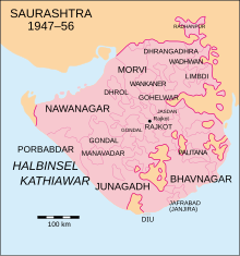
Saurashtra was created in 1947 at the end of British colonial rule in India through the amalgamation of 217 princes on the Kathiawar peninsula , many of whom, however, ruled only a few villages and who joined India in 1948. Rajkot became the capital , Rajpramukh (head of state) became the Maharaja of Nawanagar . The Muslim Maharaja of Junagadh declared on August 15, 1947 the annexation of his principality to Pakistan , which was not recognized by India. Junagadh was annexed to India and the Maharaja went into exile in Pakistan. The states of Manavadar and Mangrol also had Muslim rulers. The more than 80% Hindu population of these three states voted in a referendum in February 1948 with a large majority in favor of joining India. On February 15, 1948, the formation of the "United State of Saurashtra (Kathiawar)" was announced. The name 'Saurashtra' means something like "good state" and has been in use for the region for a long time.
The larger sub-states were: Junagadh (Sorath), Nawanagar , Porbandar , Bhavnagar , Morvi , Dhrangadhra , Wadhwan , Limbdi , Wankaner , Rajkot , Palitana , Dhrol , Gondal , Manavadar , Jasdan and Janjira . 1951 had Saurashtra an area of 55,558 km² and 4 million inhabitants.
politics
After the Constitution of the Republic of India came into force in 1950, Saurashtra became a 'B State'. The formal head was still a former ruling prince, with the title of a Rajpramukh, the actual political executive being with the chief minister and his government, which were determined by the elected parliament. During the time of Saurashtra's existence, there was a one-time election in 1951 for the 60-member parliament of Saurashtra. The Congress Party received almost two thirds of the votes and won more than 90% of the seats in parliament.
| Political party | be right | Seats | ||
|---|---|---|---|---|
| number | percent | number | percent | |
| Indian National Congress (INC) | 606.934 | 63.8% | 55 | 91.7% |
| Saurashtra Khedut Sangh (SKS) | 139,449 | 14.7% | 1 | 1.7% |
| Akhil Bharatiya Hindu Mahasabha (ABHM) | 43,043 | 4.5% | 0 | - |
| Socialist Party (SP) | 34,778 | 3.7% | 2 | 3.3% |
| Kisan Mazdoor Praja Party (KMPP) | 30,907 | 3.3% | 0 | - |
| All other parties | 20,774 | 2.2% | 0 | - |
| Independent | 75,624 | 8.0% | 2 | 3.3% |
| total | 951.509 | 100.0% | 60 | 100.0% |
In the first all-India parliamentary election in 1951/52 , Saurashtra elected 6 out of 489 members for the Lok Sabha . All 6 constituencies were won by candidates from the Congress Party. In the Rajya Sabha , the state house of the Indian parliament, Saurashtra had 4 votes out of 215.
resolution
After discussions about the territorial reorganization of the Indian federal territory from an ethnic-linguistic point of view had been ongoing for several years, this concept was essentially implemented in the 1956 States Reorganization Act . On November 1, 1956, Saurashtra was dissolved as a state and incorporated into the state of Bombay . In 1960, Bombay was also divided into the two successor states Maharashtra and Gujarat and the area of Saurashtra came to Gujarat on May 1, 1960.
Postal services
The last postage stamp from the Junagadh / Soruth Post Office was a makeshift, in which a Bhavnagar court expense stamp was imprinted with USS (United State of Saurashtra) / REVENUE / POSTAGE / SAURASHTRA.
literature
- Andreas Birken : Philatelic Atlas of British India , CD-ROM, Hamburg 2004
- Copland, Ian: The princes of India in the endgame of empire 1917-47 , Cambridge 1997. ISBN 0-521-57179-0
- Schwartzberg, Joseph E., Ed .: A historical atlas of South Asia , 2nd A., New York / Oxford 1992, ISBN 0-19-506869-6
Web links
- Imperial Gazetteer of India
- List of Princely States
- http://www.worldstatesmen.org/India_princes_K-W.html
Individual evidence
- ^ The Gazette of India Extraordinary. (pdf) The Government of India, April 17, 1950, accessed on November 6, 2015 (English, digital archive of the issues of the Gazette of India at http://www.egazette.nic.in/ ).
- ^ SN Sadasivan: Political and Administrative Integration of Princely States. Mittal Publications, New Delhi, 2005, ISBN 81-7099-968-5 . P. 26: Junagadh: Kathiawar: Formation of Saurashtra
- ↑ Virbhadra Singhji: The Rajputs of Saurashtra. Bombay Popular Prakashan, 1994, ISBN 81-7154-546-7 . P. 29
- ^ Election Results - Full Statistical Reports. Indian Election Commission, accessed on May 15, 2016 (English, election results of all Indian elections to the Lok Sabha and state parliaments since independence).
