Manavadar (State)
| Manavadar | |||||
| 1733-1947 | |||||
|
|||||
| Capital | Manavadar | ||||
| Form of government | Princely State | ||||
| surface | 574 km² | ||||
| population | 23,000 (1921) | ||||
| founding | 1733 | ||||
| resolution | October 22, 1947 | ||||
| State religion: Islam Dynasty: Babi (Yousufzai Pathan) |
|||||
| Manavadar on the Kathiawar Peninsula | |||||
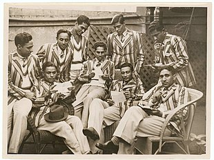
| Manavadar men's hockey team in Sydney (June 1938) | |||||
Manavadar ( Bantva-Manavadar ) was a princely state of British India in the east of the Kathiawar peninsula around the city of Bantwa in today's state of Gujarat . The principality was founded in 1733 by Khan Sahib Diler Khan Salabat Muhammad Khan Babi, brother of a Nawab of Junagadh . 1807–1947 the principality was a British protectorate . Ghulam Moinuddin Khan Fatehuddin Khan Babi (1931-1956) was promoted to Nawab. In 1921 Manavadar had an area of 574 km² and 23,000 inhabitants.
As a Muslim, like his relative in Junagadh, the Nawab decided in September 1947 to join Pakistan, but rejected this decision again, joined the Saurashtra Union and joined India on February 15, 1948 (see History of India ). On November 1, 1956, all princely states were dissolved and incorporated into the state of Bombay . When Bombay was partitioned on May 1, 1960, Manavadar became part of Gujarat .
literature
- George B. Malleson: An historical sketch of the native states of India. Longmans, Green & Co., London 1875, ( digitized version ).
- Mānāvadar. In: The Imperial Gazetteer of India. Volume 17: Mahbūbābād to Morādābād. New Edition. Clarendon Press, Oxford 1908, pp. 109-110 .
- Joseph E. Schwartzberg (Ed.): A historical atlas of South Asia (= Association for Asian Studies. Reference Series. 2). 2nd impression, with additional material. Oxford University Press, New York NY et al. 1992, ISBN 0-19-506869-6 .


