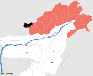
Tawang (District)
| Tawang District | |
|---|---|

|
|
| State | Arunachal Pradesh |
| Administrative headquarters : | Tawang |
| Area : | 2172 km² |
| Residents : | 49,977 (2011) |
| Website : | tawang.nic.in |
The District Tawang is a district in the Indian state of Arunachal Pradesh . The district administration is based in Tawang . The corresponding Hierarchical Administrative Subdivision Code (HASC) is: IN.AR.TA.
history
The Tawang District is located in an area that historically belongs to Tibet. Since October 6, 1984, Tawang has been an independent district in the state of Arunachal Pradesh. Before that, Tawang was part of West Kameng .
geography

The Tawang District is located in the extreme northwest of Arunachal Pradesh in the Assam Himalayas . Tawang borders Bhutan in the southwest and west , Tibet in the north and East Kameng and West Kameng in the east . The area of the district of Tawang is 2172 km². The district is traversed by the rivers Nyashang Chu and Tawang in a south and south-westerly direction.
Administrative division
Tawang consists of three sub-divisions: Tawang, Lumla and Jang.
population
According to the 2011 census, the Tawang District has 49,977 inhabitants, with a woman-to-man ratio of 701: 1000. The literacy rate is 60.61%. The 2001 census showed a population of 34,705.
Web links
Individual evidence
Coordinates: 27 ° 35 ' N , 91 ° 55' E