
Morena (district)
| Morena District मुरैना जिला |
|
|---|---|

|
|
| State | Madhya Pradesh |
| Division : | Chambal |
| Administrative headquarters : | Morena |
| Area : | 4,989 km² |
| Residents : | 1,965,970 (2011) |
| Website : | Morena District |
The Morena district ( Hindi : मुरैना जिला) is a district of the Indian state of Madhya Pradesh with about 2.1 million inhabitants. The administrative and economic center is the city of Morena , which has around 220,000 inhabitants . The district was established in 1947 and was given its current form when the Sheopur district was separated in 1998.
geography
The district of Morena is located in the northwest of the state of Madhya Pradesh in the northwestern foothills of the Vindhya Mountains at heights of 150 to 250 m above sea level. d. M. It borders in the northwest on Rajasthan , in the north Uttar Pradesh , in the east on the district Bhind , in the southeast on the district Gwalior and in the south on the district Sheopur . The most important rivers are the Chambal and its tributary, the Kwari (or Kunwari ). The most important cities are Morena (approx. 220,000), Ambah (approx. 50,000), Porsa (approx. 45,000), Sabalgarh (45,000) and Kailaras (approx. 30,000).
population
Official population statistics have only been kept and published since 1991.
| year | 1991 | 2001 | 2011 |
| Residents | 1,279,094 | 1,592,714 | 1,965,970 |
Hindus dominate the rural villages (approx. 90%); there is also a not inconsiderable number of Muslims in the cities (approx. 4% of the total population). In the decade between 2001 and 2011, the population grew by around 20% to just under 2 million, with the male population exceeding the female population by around 12%. About 76% of the population lives in rural villages; a third of the people (mostly women) are considered illiterate. Mostly Hindi is spoken .
economy
Agriculture has traditionally played the dominant role in the district's economic life; The main crops are soybeans , lentils , wheat and rapeseed . Crafts, trade and smaller industrial and service companies have settled in the cities.
History and sights

The area around Gwalior and Morena played a not insignificant role in Indian history - several important medieval temple sites were built here: About 25 km northeast of Gwalior and a good 40 km southeast of Morena is the small town of Naresar with a large number of small to medium-sized temples from the Pratihara period (7th to 10th centuries). Approx. 12 km northwest of the town of Aiti there is a small, towerless temple from later times with an elongated vestibule ( mandapa ); Another 10 km to the north is the round Chausath Yogini Temple of Mitaoli (also Mitawali or Mitauli ). The temple complex of Bateshwar with over 200 individual temples extends about 5 km west of Mitauli in a basin near Padhawali ; The Shiva temple in the Padhawali Fort is also of extraordinary artistic quality. Approx. 20 km north of Mitaoli near Sihoniya are the still imposing ruins of the Kakan Math temple and several Jain temples.
Under the Mughal ruler Jahangir , the city of Nurabad , 14 km southeast of Morena, was established in the 17th century ; the fort above the city of Sabalgarh also dates from that time.

Naresar , temple

Aiti , Shiva temple

Mitauli , 64 Yogini Temple
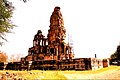
Sihonya, Kakan Math Temple
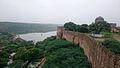
Sabalgarh , fort
.jpg)
.jpg)
.jpg)


Web links
- District Morena, sights - photo + information (English)
- District Morena, sights - photo + information (English)
- District Morena, sights - aerial photos + information (English)
- Garhi-Padawali Temple - Photos and information (English)
Individual evidence
- ^ Morena district - Census 2011
- ↑ Morena and surroundings - map with altitude information
- ↑ Morena District - Map and brief information
- ^ Morena district - Census 1991 to 2011
- ^ Morena District - Religious Affiliation
- ^ Morena district - Census 2011
- ^ District Morena - Economy
Small text

Agar Malwa | Alirajpur | Anuppur | Ashoknagar | Balaghat | Barwani | Betul | Bhind | Bhopal | Burhanpur | Chhatarpur | Chhindwara | Damoh | Datia | Dewas | Dhar | Dindori | Guna | Gwalior | Harda | Hoshangabad | Indore | Jabalpur | Jhabua | Katni | Khandwa | Khargone | Mandla | Mandsaur | Morena | Narsinghpur | Neemuch | Panna | Raise | Rajgarh | Ratlam | Rewa | Sagar | Satna | Sehore | Seoni | Shahdol | Shajapur | Sheopur | Shivpuri | Sidhi | Singrauli | Tikamgarh | Ujjain | Umaria | Vidisha