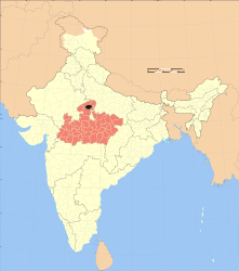
Gwalior (district)
| Gwalior district | |
|---|---|

|
|
| State | Madhya Pradesh |
| Division : | Gwalior |
| Administrative headquarters : | Gwalior |
| Area : | 4560 km² |
| Residents : | 2,032,036 (as of 2011) |
| Population density : | 446 inhabitants / km² |
| Website : | www.gwalior.nic.in |
Gwalior is a district in the Indian state of Madhya Pradesh .
The district is located in the north of Madhya Pradesh. It has an area of 4560 km². The district administration is located in the city of Gwalior .
population
In the Gwalior district there were 2,032,036 people living in the 2011 census. 10 years earlier it was 1,632,109. The gender ratio is 864 women per 1,000 men. The literacy rate is 76.65% (84.70% for men, 57.38% for women). 90% of the population are followers of Hinduism , just under 7% are Muslims , 1.22% are Sikhs and 0.89% are followers of Jainism .
Administrative division
The district is divided into 3 tehsils :
The city of Gwalior is the only municipal corporation in the district. With Morar Cantonment there is a garrison town with the status of a Cantonment Board . There is also the city of Dabra as the only Nagar Palika Parishad .
The following Nagar Panchayats are located in Gwalior District :
history
Gwalior District was established in 1956 when Madhya Bharat became part of Madhya Pradesh . Before that, between 1761 and 1948, the princely state of Gwalior was in the area of today's district.
Web links
Individual evidence
Small text
