
Gwalior
| Gwalior ग्वालियर |
|||
|---|---|---|---|
|
|||
| State : |
|
||
| State : | Madhya Pradesh | ||
| District : | Gwalior | ||
| Location : | 26 ° 13 ' N , 78 ° 11' E | ||
| Height : | 210 m | ||
| Area : | 173.68 km² | ||
|
Inhabitants : - Agglomeration : |
1,069,276 (2011) 1,117,740 (2011) |
||
| Population density : | 6157 inhabitants / km² | ||
| Website : | Gwalior | ||
 |
|||

Gwalior ( Hindi : ग्वालियर , Gvāliyar ) is a city of millions in the Indian state of Madhya Pradesh . It is the capital of the district of the same name and one of the most historically and culturally significant cities in India.
location
The city of Gwalior is located about 340 km (driving distance) south of the Indian capital Delhi or about 120 km south of Agra in the northern foothills of the Vindhya Mountains in the transition to the Ganges plain at a height of about 210 m above sea level. d. M. The climate is temperate by Indian standards; Rain (approx. 910 mm / year) mostly only falls in the summer monsoon months .

population
Official population statistics have only been kept and published since 1991.
| year | 1991 | 2001 | 2011 |
| Residents | 690.765 | 827.026 | 1,069,276 |
Most of the residents who immigrated from rural regions are around 89% Hindus and around 8.5% Muslim ; Christians , Jains , Sikhs and Buddhists form small splinter groups. As is usual in northern India, the male population is significantly higher than the female. Speak Hindi , Marathi and English.
economy
Agriculture in the surrounding villages traditionally forms the livelihood of the urban population, which mostly consists of small traders, craftsmen, day laborers and service providers of all kinds. The shoe, textile, paper, cigarette and food industries are economically important; In the second half of the 20th century, an important chemical industry also settled. There are several universities and institutes.
history
The approx. 150 m high striking castle hill above the plain is likely to have served as a refuge for people in earlier times. In the Mahabharata , a place called Gopalkaksh is mentioned, which some researchers identify with Gopadri or Gopagiri - both of which are ancient names of Gwalior. In the 5th century, Suraj Sen , a Rajput prince from the Kachwahas tribe , took the castle hill, which subsequently changed hands several times. In 1021 Mahmud's troops of Ghaznis conquered the castle hill and the settlement at its feet; in 1231 the city and fort were taken by Sultan Iltutmish . With the increasing weakness of the Sultanate of Delhi , regional Hindu princes from the Tomar tribe , including Man Singh (r. 1486–1516), gained the upper hand, but after years of conflict he was defeated by the Delhi-based Lodi dynasty , who, however, opposed themselves a few years later (1526) had to bow to the Mughals under Babur . After the death of the last major United Mughals , Aurangzeb (1707) the vast Mughal empire collapsed - several provinces made themselves independent and outside, new powers (mixed Jats , Marathas , British ) one. Around 1725 a Marathen general founded the Scindia dynasty and the princely state of Gwalior , which also continued to exist under British rule. The British ensured stable conditions, but in 1857 everything was shaken during the Sepoy uprising and had to be fought with enormous military action - Gwalior was a center of the insurgent soldiers. In 1948 the princely state of Gwalior was incorporated into the Indian Union ; eight years later (1956) the state of Madhya Pradesh was established .
Attractions
Castle Hill

The city is dominated by a 150 m high table mountain ( Fort Gwalior ) secured by a total of seven gateways . Most of the sights are located here:
- Several standing and seated Jain - Tirthankaras were carved from the 7th to the 15th Century from the rock. The largest figure represents Rishabha (or Adinath ) and is almost 18 m high. The heads of the statues were destroyed by order of Babur , but later replaced.
- The Man Singh Palace, which is decorated with colored tiles, was built around 1500 and combines Hindu and Islamic decorative elements. He was called a "pearl" by the Mughal Mughal Babur.
- The Gurjari Palace dates from the same period and was built for Man Singh's favorite wife. Today it houses an archaeological museum.
- The towering Teli-ka-Mandir from the 8th century is one of the most idiosyncratic Hindu temples of all.
- An inscription from the 9th century in the small Ganesh temple shows the number "0" for the first time in India.
- The two - restored - Sas-Bahu temples date from the 11th century to protect against rainwater and wild animals on a platform ( jagati ); they have nothing to do with mother-in-law ( sas ) and daughter-in-law ( bahu ), but are consecrated to the Hindu god Vishnu under his surname Shashtra Bahu . The open, almost floating architecture of the main temple, which is reminiscent of Jain buildings (e.g. Ranakpur ), is impressive .

Jain characters

Gate to the fort

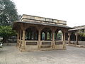
Man Singh Palace

Sas Bahu Temple


Lower town
- The most important historical building in the lower town is the Ghaus Mohammed mausoleum, built in the second half of the 16th century in honor of a Sufi saint. The square, but with numerous protrusions and roof pavilions ( chhatris ), is raised by a central dome and enclosed by finely crafted Jali windows.
- There are other tombs and cenotaphs in its vicinity , including the mausoleum for the musician Tansen .
- The Jai Vilas Palace , built in European style at the end of the 19th century, is now a museum.
- The sun temple, donated by the industrial family Birla in the 1980s, is dedicated to the sun god Surya . The temple, standing on a stone chariot drawn by seven horses, is a scaled-down replica of the Konark Sun Temple .

Ghaus Mohammad Mausoleum

Jali window
Tansen mausoleum

Town Hall
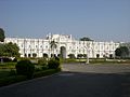
Jai Vilas Palace

Surya Temple (also Birla Temple )
.jpg)
.jpg)
.jpg)


Surroundings
There are several important temples and temple complexes within a 50 km radius of Gwalior; in particular the places or sites of Naresar , Mitaoli , Pidhawali , Aiti , Bateshwar in the Morena district should be mentioned, but the Mughal ruins of Nurabad also deserve attention. The two temples of Amrol are located around 25 km south of Gwalior .
sons and daughters of the town
- Tansen (≈1506–1589), court musician of the Mughal emperor Akbar
- Atal Bihari Vajpayee (1924–2018), politician and Prime Minister of India
- Raghunath Seth (1931–2014), Bansuri player and composer
- Javed Akhtar (* 1945), screenwriter, poet and songwriter for Hindi films
- Amjad Ali Khan (* 1945), sarod player and music teacher
- Aditi Mutatkar (* 1987), badminton player
Web links
- Gwalior, History - Info (English)
- Gwalior, Man Singh Palace - Photos and information (English)
- Gwalior, Mohammed-Ghaus-Mausoleum - photos + information (English)
- Gwalior, Surya Temple - Photos + Info (English)
Individual evidence
- ↑ Gwalior - Census 2011
- ↑ Gwalior - Census 2011
- ↑ Gwalior - Map with altitude information
- ↑ Gwalior - climate tables
- ^ Gwalior - City Population 1991-2011
- ↑ Gwalior - Census 2011
- ^ Gwalior Industry
- ↑ Gwalior - Economy
- ↑ Gwalior - History
- ↑ Gwalior, number “0” - photos + information
- ↑ Gwalior, number “0” - discussion