Sagar (India)
| Sagar | ||
|---|---|---|
|
|
||
| State : |
|
|
| State : | Madhya Pradesh | |
| District : | Sagar | |
| Sub-district : | Sagar | |
| Location : | 23 ° 50 ′ N , 78 ° 44 ′ E | |
| Height : | 525 m | |
| Area : | 34.26 km² | |
| Residents : | 274,556 (2011) | |
| Population density : | 8014 inhabitants / km² | |
| Website : | Sagar | |
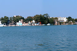
| Sagar from Lake Lakha Banjara | ||
Sagar ( Hindi : सागर , Sāgar ; Urdu : ساگر) is a city with approx. 300,000 inhabitants in the east of the central Indian state of Madhya Pradesh . The city is the administrative seat of the district of the same name .
location
Sagar lies at an altitude of approx. 525 m above sea level. d. M. on Lake Lakha Banjara and is surrounded by the northern foothills of the Vindhyagebirge ( Dekkan ). The megacity of Bhopal is just 170 km (driving distance) to the southwest. The climate is warm to hot; Rain (approx. 1200 mm / year) falls almost exclusively during the summer monsoon months.
population
As a result of the sustained population growth in large parts of northern India and due to immigration, the city's population has increased enormously in recent decades:
| year | 1991 | 2001 | 2011 |
| Residents | 195.346 | 239,578 | 274,556 |
The population of Sagar consists mainly of Hindus (approx. 81.5%), Muslims (a good 10%) and Jains (a good 7%); smaller minorities are Sikhs , Christians and Buddhists . As is customary in censuses in India, the male population clearly exceeds the female population. One speaks mostly Bundeli and Hindi .
economy
Agriculture ( chickpeas , wheat , oilseeds, etc.) in the area has formed the basis of economic life for thousands of years; Traders, craftsmen and service providers of all kinds have settled in the city itself. Numerous oil mills and fertilizer companies have set up shop in and around Sagar . Sagar is an important regional transport hub.
history
Little is known about the ancient and medieval history of the region; it was a tribal area, but officially belonged to the Mughal Empire . In 1660 Udan Shah founded a fortress ( fort ) and the Parkota settlement , which is now a district of Sagar. With the fall of the Mughal empire after Aurangzeb's death , the region fell to the Marathas ; in 1735 Govind Pant made Bundele Sagar the capital of his small empire. Peshwa Baji Rao II handed the area over to the British in 1818 . The area historically belonged to the Bundelkhand region , but in 1836 it was annexed to the newly created North-Western Provinces . It has belonged to the state of Madhya Pradesh since 1956.
Culture and sights
The city of Sagar has no medieval monuments. Some forts in the area are interesting.

